Sunday, December 18, 2016

Tocayo

Last weekend I spent a long one visiting Nuestro Pequenos Hermanos (NPH) - my project currently underway in Honduras - to take stock of progress.  To remind, we are constructing a dormitory and large conference facility to host medical bridgades and to host seminars for local medical teams.  And I suppose, there will be purposes served in this large meeting room for the children and staff of the orphanage.  (See my earlier post: Brick By Brick)

Oh yes, I did take detailed stock of the progress, assessing conditions, reviewing details, clarifying the details of design, and reporting on the general progress representing as good a quality of construction as Honduras can produce under these circumstances.  I am pleased and excited by the prospect of completion, quite likely to happen by the first of March.  Proverbial light at the end of this long tunnel.
View of the front of the Conference Center

The center courtyard emerges, dormitory surrounding


Half of the main meeting room, view toward the stage, with cupola above

Rubble walls under construction, with dormitory wing beyond

But what really delighted me last weekend is being able to spend so much time with Axel, my god child whom I sponsor - my tocayo - two people who share the same name.  He turned 17 in August, recently graduated from high school, and must now complete his year of service to NPH before attending college, with the ambition to become a doctor.  So with the weekend largely free, Axel spent in tow of my inspections, tutoring me on my nascent yet emerging Spanish, and visiting with other "pequenos hermanos".  

Two Axel's - "nosotros estamos tocayo" - on the mountaintop

Sunset from the mountaintop
We hiked to the mountaintop to take in the sunset.   I brought him some watercolor pencils for Christmas that, around the table, were tested on an unusual still life of wine and hot sauce.  I brought a gift to Zuany from her "madrino", my co-worker Megan, and spent an hour goofing around with her Casa Suyapa roommates, with my resemblance to Santa Claus not missed on them.  And though Axel absolutely demolished me in a game of chess, a  tense game with Isaac in the clinic, born with aids, ended barely in my favor.  
 
Zuany with her new "trolls"

Clowning around

A game of chess with Isaac in the clinic

Axel creating his still life - he is quite an artist


A brilliant sunset from Casa Romano

And I suppose I just wore the poor lad out!
 Though the weather was mostly wet, a bit unusual for this time of year, it contributed nothing toward dampening my enthusiasm and delight with this visit.  Bricks and mortar are important as shelter, but these relationships are so important to the pequenos in any weather, hopefully reinforcing their foundations.  I am so honored to be a part of both these projects!
 

Wednesday, November 30, 2016

Still a Civil War?

Yesterday was a fairly dramatic day  in the mundane life of a lowly State Capitol Preservation Commission "public member", as I am.  Having  also been assigned to the Art in the Capitol Subcommittee, I did gain quite a bit of knowledge and thoughtfulness on the appropriateness of art in the capitol, especially "controversial" art.  Yesterday, the issue of keeping the six paintings depicting Minnesota's famous Civil War regiments on display in the splendidly rich Governor's Reception Room and Anteroom came to a head, with the Governor himself storming out of the meeting claiming partisan politics at play.  I was in the sausage factory!  But I have had no political ax to grind in this Commission appointment, but only my perceptions of what is the right thing to do.    

And so I delivered my one opinion, as follows, amid all the political noise:

My Fellow Commissioners,                                                   November 29, 2016

I have greatly appreciated the opportunity to serve on this commission, but especially the Art Subcommittee, where I have had an extraordinary personal learning experience, gaining not only an appreciation, but a deeper understanding the public appreciation for our State Capitol.  It is truly a national monument, not only to the architecture of native son Cass Gilbert, but to the builders of our very State, and the defenders of our very existence as a unified country.

History matters, and art matters.

That is why the Civil War paintings must remain in the Governor's reception room.  They were designed for this room, and this room, and the capitol itself, is a monument to these veterans.  Can you imagine the rotunda without the paintings?  The chambers?  All the paintings make this Capitol so very special.

Why do I argue so?

Some might say this is inconsistent with my support to relocate, within the Capitol, the Treaty of Traverse Des Sioux and the Father Hennepin paintings.  Initially, I was opposed to this, preferring to keep the Reception Room as it was, but I was persuaded by my colleagues that Father Hennepin was simply not accurate in its depiction.  Traverse des Sioux is no different, in my view, than a photograph by Matthew Brady would have been of the same event - it is a moment in time, and is more or less accurately represented without overt bias.  But I have come to understand how this defining event of our State's existence still inflicts pain on the Indian community, but whom I think will agree that even these tragic events should never be forgotten, but appropriately interpreted so we can learn from them.

We think nothing of looking at the Matthew Brady photos of the Civil War, as emotional as they are, vivid in their portrayal of ordinary men in extraordinary circumstances, and are moved by the horror of the battlefield, be it blue or gray.  If we put those photos in a back closet, never to see the horrors of what a civil war can wrought, how would our descendants ever truly learn?  How would the horrors of civil war ever really come to life?  Civil war is a historical fact around the globe, with most nations having experienced a defining civil war as part of their heritage, so we are not alone in suffering the pain of internal conflict, and we need  only read the current headlines to know civil war has sadly not been extinguished by humanity.  I am sincere in my opinion that these paintings, none romanticized, all depicting historically accurate events with ordinary Minnesotans doing extraordinary service, do more to reinforce how fragile our nation's very fabric was during this war.  
We were so close to shredding that fabric in the early 1860's, to having the United States as we know it today not even exist. Lincoln was perilously close to losing it all, his fight for abolishing slavery sliding precariously toward defeat.  Even the English and the French were close to entering the war - on the side of the confederation - merely to protect their cotton trade, and preserve the status quo for their own benefit.
 
The Minnesota regiments were at the forefront of protecting liberty for all, for the State, the Nation, and all of us as citizen descendants - they were "our" veterans in the same way we honor more recent veterans for their sacrifices.  We would no more "relocate" their monuments than we should for these Civil War veterans - common men making great sacrifice for our way of life, critically supported by the women and families here at home, assuring our free nation and State for all Minnesotans today.  They played a hugely critical role in the War - let's honor that in the best room in the people's house.

In my humble opinion, if it is even that, there is no room more honorable for their sacrifice and enduring legacy than the Governor's Reception Room.  But in order for the lessons to be learned by our present and future generations, these painting must be interpreted, so the lessons of this horrific conflict are never lost on our present and future visitors.  And further, these paintings are sufficiently large that to relocate  them elsewhere in the capitol would take up the important, valuable "real estate of wall space" needed to tell all the other great stories that need to be told.

Please, my fellow colleagues, keep the civil war paintings in the place of honor originally planned for them, as their monument, and let's continue to honor and learn from their sacrifices.

The Second Minnesota Regiment at Missionary Ridge (Gettysburg) Nov 24, 1863
Painted by Douglas Volk

This was received with applause by the audience, including a contingent of veterans, ironically delivered in the Veterans Services Building (temporary  quarters of the Governor during the restoration), and even a  "sign on" from several of the Senator's and representatives in  attendance.  And eventually, the vote reflected my position, now in the hands of the Minnesota State Historical  Society.  And as I approached the building before the meeting, I was struck by all the war memorials on the Capitol lawn, and thought we would never approve removing these memorials that each tell their own important story to some other location simply  in the interest of change times and thoughts.

What is perhaps most interesting, is that all the local media carried the story, (including  the Pioneer Press citing a part of this speech) not as much  about the art itself, but about the Governor walking out of the meeting!  That action probably did more to call public attention to this important issue, then all  the good work  that went into just getting  to this point!

In politics, the war is no longer civil, to be certain, and as history will inform, never has been.

Monday, August 29, 2016

Offa's Dyke, Part II: Angles and Angels

This Welsh/English borderland is idyllic.  Literally bathed in copious amounts of rain, tempered by a relatively mild climate, rich in the diversity of plants and trees, and ideal for all manner of agricultural purposes, not the least of which is sheep and cows.  From a perspective of terrain, it is most like the Appalachians to me, or even the Berkshires in New England.  I can easily see why the English settlers could so readily identify with New England - rolling, green, lots of stone and timber - just like "home".

Typical Welsh scenery - Disgwylfa Ridge

Into this landscape we started walking - Wednesday August 24th.  Crossing fields of sheep (well fertilized, I might add, some of which we carried on our boots), hay, hedged verges, hardwood and coniferous forests, narrow lanes passing into small villages seems to define our walk.  But the big hills: Herrock, Rushock, Hergest Ridge, Disgwylfa presented their own challenges, steep up and down, largely bald on top with large, windy open spaces covered in bracken (fern fens easily 5' high) with great views. And then came Hay Bluff and Hatterrall ("Hattie") Ridge.

Hay-on-Wye is a small town known for its many bookshops - mostly antiquarian - started with an 11th century castle atop a short bluff with excellent visual angles up and down the Wye River.  Following a long day of hiking across these high hills, Hay was a welcome sight, a town of narrow twisted lanes surrounding the castle, and within the oldest structure in town, a "freehouse" (pub) called Three Tuns, we enjoyed a world class pub fare and a detailed introduction to how these old wattle and daub structures were built (note: people were much shorter than me!). Knowing we were at the low part of the valley, Hattie was calling just as the day slipped to nightfall.

We departed the B&B at our usual time - around 9:15 following a full English breakfast - and wandered back through town to find the trailhead south, and in so doing found ourselves in a public parking lot trying to locate where the trail started up.  We were not alone in the endeavor, for another hiker was also seeking the trailhead, and so, with a bit of guidance from a local who "thought" it lead in a certain direction we three headed for Hattie.

Enter Tracey Brittle.

Now it is customary to exchange the usual information about your trip, especially if headed in the same direction.  As we were walking across the field, such information was exchanged, but there occurs that awkward moment when a subtle agreement is silently made about walking together, at least for a short spell.  That moment was somewhere in this first field crossing, when you would like to say "please join us for a spell" but your polite gene instead says "please don't let me/us hold you up, with such a long climb ahead", stated under the near certain presumption that they must be faster, that they want their peace and quiet, and really are here to get away from it all, including me/us. Indeed, such was offered, vigorously, but Tracey and us, but we just kept walking, instead saying "no, its fine, we/I would love the company", at least for the next mile or so, as you are certain this cannot last, as the perfunctory questions are asked and answered - the who/what/where/why and when questions.

Tracey and Becky spurring each other on the way up.

But then the hill started to get a bit steep.  What we all discovered upon cresting the first shoulder of the climb, was that Becky and Tracey, in their near constant chatter, did not become immediately aware that they were actually making good progress, that they were both not fast, and that they both liked to "pause to take in the view" frequently and at the same time when none necessarily existed.  In that 2008 foot ascent from Hay-on-Wye to the crest of Hattie Ridge, they bonded pretty solidly  They were trail angels to each other, for they both dreaded the prospect of the long and steep climb ahead, but delighted in getting to the top together.  They broke the demons in their heads that always poke your mind trying to hold you back.

Cresting Hattie ridge - Becky and Tracey down there somewhere
And for me?  I too was delighted, for I could walk my walk, as I tend to be a bounder moving quickly, eager to get to the top where the views are, and navigating the twists and turns of the way forward.  When I knew the pathway was clear (for there were no trees), I said I would meet you at the top.  I found a perfect resting spot on a rock ledge overlooking the saddle we just summited, and took great delight to finally see them both, walking together, taking their time, and chattering away, for I could hear them easily across this great open expanse. 

Taking a break near the crest of Hattie ridge

The Hatterrsall ridge is simply amazing.  While overcast, it was not raining. I have never been on such a long continuous ridge, devoid of any trees, with sweeping views 360 degrees at all times.  And it was boggy on top, which seems to defy logic - the ground cover is expansive areas of grasses, heather and bracken, all of which thrive on moist soils that peat would provide.  So the crest was one long bog, with many areas having large stepping stones to walk upon.  There were sheep, but also small herds of wild ponies. I was moving excitedly across this space, leading and awaiting Tracey and Becky, as I could see them from a great distance ahead.  It was pure magic up there.


Long views over fields of heather
But alas, good things come to an end.  The ridge is so long that we could not complete it in a day, and so a trail crossing down each side of the ridge lead to Longtown where Becky and I were headed on the east side, and  the Priory where Tracey was headed on the west.  You know it is coming.  You think about it.  It comes.  You hug, thank each other for the great day, and wish good luck on the way ahead.  And then you head down, down, down, losing this valuable ground you worked so hard to gain, knowing (or dreading perhaps) that come morning, you would have to climb up to the ridge again.  

The morning of Thursday, August 25th was deeply overcast and damp, and Hattie's ridge, clearly visible in the evening sky last night, was shrouded in thick cloud cover, invisible. Into this cloud deck we started walking, slowly skirting the side of the ridge.  When I knew Becky's pathway was clear to the saddle, I told her I would meet her at the top, and proceeded to bound up, causing the sheep to skitter into the thick bracken, and disappear, white on white.  As soon as I crested, I noted a familiar figure taking a picture - Tracey coincidently arrived but a few moments before me, and so we cancelled our previous farewell, rehearsed the usual "are you sure you and Becky . . ." with animated protestations to the contrary, and sat awaiting Becky, commenting that the dense fog in this high place enables one to experience complete silence. As we sat quietly to test this theory, Tracey thought she heard footsteps, and so Becky arrived but 20 minutes behind us into this white fog, equally surprised and delighted to have her hiking angel back.  And so we began day two, hiking up to Hattie, only to hike down again!

Horses in heather and fog
Hattie was different this day - no view at all.  I stayed close by so we could be sure to navigate the correct trail in this fog.  It would probably not make most hikers happy but for us, it was a way to experience Hattie in quite a different mood.  The wild ponies seemed to appear out of the mist, as if in a Sherlock Holmes story - eerie, quiet, calm, moving quietly amidst the heather, muted in color yet glistening with dew.  Gradually we descended this long mountain, back into the valley of fields, vales and wood plots.  And it turns out, we were all headed to the same very small town - Llangattock Lingoed.  Following a long enjoyable dinner with an English ex-pat couple of walkers from Cyprus at the Hunters Moon Inn and freehouse, we again said our goodbyes, for Laura joined us from London, late and in from the rain to complete our trip.

Two Hikers Cowed

Friday, August 26th greeted us from our amazing picture window in the Old Rectory B&B with bright sunshine and a clear blue sky.  We departed, as was our custom, around 9:15 and visited the small, very old Norman era St. Cadoc's church across the way.  And once again, Tracey appeared, though perhaps the mutual trail angel characteristics that both Becky and Tracey exhibited are best displayed in just such a church, with mutual delight at having company yet a third, though known-to-be final day, for Tracey was hiking farther to Monmouth.  And so we enjoyed a beautifully clear day of relatively easy, pastoral walking, and the company of both Laura and Tracey, until the Old Hendre Farm where we were staying.  So with the practice of two previous evenings, we did finally part company, full of sincere warm feelings, and most especially between Becky and Tracey, for having shared this rich experience together.

Who knew it could be so fun!  And goofy . . .
In all of my travels, I have experienced similar situations, and have told Becky about them, but it is hard to comprehend the level of personal enrichment these sorts of interactions enable.  It does support the notion that people really do need people, and that you never know when that need will manifest itself and be answered in an unexpected way. 


Thank you Tracey, for enriching our lives and our wanderings, for though it was one stop on our longer journey, it is one we will remember and cherish.  Until we meet again . . 


Friday, August 26, 2016

Offa's Dyke, Part 1: Tracing History

What a massive earthwork undertaking this was, and who really knows of it?  The Romans had their Hadrian's Wall, the Chinese the Great Wall, both less of an earthwork project and more of a masonry rampart.  The Mercia Kingdom had their dyke - Offa's Dyke.  We are following that undertaking with one of our own, hiking 87 miles from Knighton to Chepstow, Wales, the southern half of the 177 mile length of this trail.

The dyke, clearly discernable between Knighton and Kington
The Anglo-Saxon's, of northern Germanic and Danish descent, gradually filled the vacuum left by the Romans departing England in 406 AD with seven "kingdoms".  Following a civil war in 757AD, Offa became the ruler of the Mercian kingdom, somewhat brutally, of what we now know to be central England. Though desiring the rich territory of  Wales, west of England and representing the "native" English who migrated away from the Anglo-Saxon invaders at the time, two forays into Wales to expand his territory failed due to the fierce independence of the Welsh.   So if you can't fight 'em, build a barrier, as much a protection of Mercia from the Welsh as protecting the Welsh from further forays into Wales by the Mercians (and they did not have to "pay" for it!).  Offa undertook this massive rampart for 59 miles of the 64 mile border between Powrys (in Wales) and Mercia, north to south.

The "logo" for the trail: Offa's image from the penny coin
Though not merely a ruthless ruler, Offa did have larger global ambitions for trade, and existing records indicate a correspondence and visit with Charlemagne, thought to be the first record of a meeting between two European leaders, as well as a visit by the Pope in 786AD.  He also established the English penny to facilitate trade, which bore his likeness and the phrase "Rex Anglorum" - King of England, which is the basis for the Offa's Dyke logo, seen on many signposts.  He died in 796AD, and thereafter his accomplishments were superseded by more famous Kings, including it is supposed, King Arthur (or is that merely legend?)

One theory on how it was constructed (Hill and Worthington) suggests that  a total of 5000 men were needed, divided among village leaders each being responsible for the peasant labor to build a section of the dyke that is roughly 4' long of a deep and wide ditch per man, from which the spoils would build an equally high dike, up to 8 meters high, atop which a palisade wall was placed.  With a lot of rock as well as clay soils, personally evidenced along the walk, a variety of materials and techniques were likely used, the bulk of which was pure manpower. 

More dyke walk - defining a boundary between fields and nations
Today, this dyke has, except along certain stretches, mostly disappeared, but has defined, more or less, the boundary between Wales and England, and over the southern half, created a "crossover" area called the Welsh Marches, where the boundary seems arbitrary, and the people identify both as Welsh and English - peaceably now at least!


Remains of the dyke in the uplands - well worn and diminished
What has been so interesting about walking this dyke is the sense of some man no different than me in every earthly respect, actually building this.  It is as if I am walking in their shoes, imagining the alignment across this varied landscape, the organization of the workforce, the sheer logistics to getting this accomplished, especially in the very high and barren Black Mountains area, themselves a significant barrier.  Even to see a farm fence and thick hedgerow, and in places enormously large oak trees that themselves could be almost as old as the wall, seems to validate the historical significance of this barrier.

And the prevailing question is, even as you walk it, did it really matter any more than simply as a political boundary - a "line in the sand"?  A monument to a royal ego? A "make work" defensive infrastructure project with limited value in actually accomplishing its goals, whom the locals routinely circumvented to trade among each other within the synonymous agricultural lifestyle on each side of the wall? 


Questions that sound as eerily applicable today as 1200 years ago. . .

Thursday, August 25, 2016

Change in Time - Change in Values


During the course of our England visit, I had on my list to visit Chatsworth House, the large, impressive estate of the Duke(s) of Devonshire, the gardens of which were originally designed by the preeminent landscape architect Capability Brown in 1758-66 under the fourth Duke of Devonshire, and later maintained and expanded by Joseph Paxton, the object of my particular study and the point of this visit.  Joseph Paxton was the architect of the 1851 Crystal Palace for the World Exposition, but was really a landscape planner and manager - a "gardener's boy" according to Queen Victoria - for the sixth Duke of Devonshire as his patron.  I wanted to see these gardens, his greenhouses, and to get the sense of the place and all that inspired the Crystal Palace.


Chatsworth House on the Derwent River
It is magnificent, to say the least, well maintained, very popular, active gardens.  The house is a demonstration of the various Duke's commitment to art and other worldly pursuits over the centuries, sumptuous in its abundant decor, ceiling murals depicting scenes that could be construed as deference to the King - in a word, over-the-top.  It is said that much of the rich work done in these rooms was to impress the King upon a visit therefrom, such visit had never come until Queen Victoria visited Paxton's lily house.  All that effort and expense just to please your Highness.  What would the peasants think if they could even have seen.  But such a treasure the site and estate is for its promotion and preservation of some priceless art and grounds.

Only one tiny part of the gardens - and Paxton's greenhouses

The private Chapel at Chatsworth
Just the day before, staying in the town of Bakewell, Becky and I hiked the several miles on a wet and muddy track to Haddon Hall, not realizing ahead of time that it existed, and  that we could take the time to visit it and get a bit of walking in before our longer journey.  We arrived at this 11th -14th century Tudor/Elizabethan estate, muddy and a bit wet, thinking we would not gain admission (even though wet and muddy seems a common trait in these parts of  the English Peaks District).  But we did get in, and were completely humbled and taken in by the simplicity of the place, the hallowed sense of the place, indeed, it was as if the ancestors merely left and made no special attempt to shut the door! It was as if transported back in time, especially the tiny, austere, and very simple chapel.  The great hall with its stone floor and walk-in fireplace where events were held might have hosted one yesterday.  And the rooms, while certainly opulent for their time, did not seem overly so.  And even as a visited site, the Rutland family still lives there, accommodates visitors simply with no guided path or audio guides, able to almost sense the living in this place.  And there were not that many visitors.  It was a remarkable step back in time, and so completely unlike Chatsworth House, both as a visiting experience, and in its very creation, that made the rain and mud quite worth it.

The Inner Court at Haddon Hall

Haddon Hall from the excellent English gardens


A detail of the "fresco" at Haddon Hall private Chapel - note the skeletal figure


Hiking back to Bakewell over the hills and vales of the Derbyshire countryside gave me an opportunity to reflect on these two distinct places, and what life must have been like - was it really any different?


Thursday, August 18, 2016

Landfort - A Step Back In Time

Last Monday, in an unusually clear Dutch morning, I left our B&B in the tiny town of Megchelen and drove the 4 or so kilometers to Landfort, specifically to catch the spirit of the place in the morning sunrise.  And what spirits I did catch!

In a previous post last summer during my bicycle trip in upstate New York, I passed a touring couple from the Netherlands, who revealed their knowledge, interest and excitement of Landfort on this serendipitous moment over twenty or so miles, and their residence being but a few kilometers away in Ulft.  This summer, we arranged a visit to Joost and Rieneke van der Plicht, the Luyken biographer Aggie Daniels, and the much younger cousin of my father whom we never knew about, Bertie Luyken Wennick.  Joost and Bertie were able to arrange a personal tour of this legendary house, now in private ownership, but as a protected estate - similar to the National Trust for Historic Preservation.  This was a once in a lifetime opportunity for Laura, Becky and me to see this place, last visited by me as a 12 year old in 1968 with my father when it was a ramschackle mess (and unable to gain entrance), and then again in 2003 with Laura, but only from the distance. Now was the time to see this place my father and aunt spoke so glowingly about.

The central part of the house was (apparently) built over an even older structure destroyed by fire, in 1434 as a small "kasteel," with four onion domes in each corner added in 1671, and a double moat system fed from the Issel River adjacent the property, separating Germany from this region in Holland - Gelderland.

The house had 32 owners  over 391 years before being acquired by my great-great-great-grandfather Dr. Johan Albert Luyken in 1823.  In 1825, he added the two wings and completely remodeled the castle to be more of a grand estate home, and hired a very famous landscape designer, Jan David Zocher, to design the grounds. The Luyken family had ownership, through both world wars, though it was heavily damaged in World War II, until 1970, when, facing extensive cost to restore and no means to do so, it was sold the Stichting Geldersch Landschap, the preservation society.  Restoration was delayed for some time, while the house continued to decline, partly from squatters, and finally undertaken from 1998 through 2003, and most of the grounds outside the moat system is now a public park.


This visit culminated a long held wish last Sunday to truly see this magnificent place, top to bottom. Invited by the current owner, Mr. Peter Rutten, we toured the main living spaces, the basement, and the attic. Though there are many original elements in the house - the ornate heat stoves, the fireplaces, the cistern pump, even the "orangerie" (a heated winter solarium for growing fruit, one of only two in all of the Netherlands) - there are also many modern conveniences installed, and so but for the organization of the spaces and the volumes, it is not our house anymore, nor should it be. I could look past this. We enjoyed drinks on the terrace.  We talked of the place, the history, and even politics.  I would argue that even that last point had been repeated over the previous centuries, perhaps in this very spot.

The Issel River
I only wish my father could have known about this visit, and even participated, for it was he that had sparked my imagination of the place, recalling his stories of his summers spent in youthful mischief with his twin cousins of the same age.  I will never forget watching him from the safety of the moat bridge, knocking on the front door of this spooky mansion, peering in as best he could, quite certain that a hermit of a relative did not want to answer (in fact, no one was home, for Bertie and her brother Albert were living there at the time, but in only half the house).


The Iron Bridge over the moat

Walking through the woods around Landfort the following morning, the quiet magic of the place revealed itself to me.  The light dappled through the dense towering canopy of trees, some of which could easily have been hide-n-seek spots for Dad.  The meadows twinkling with dew in the low sun, rippled with bands of wildflowers, certainly picked to please Tante Bars (my Dad's favorite aunt) with a favor in return.  The location of the bridge embankment across the Issel, marked by rubble and a few towering trees marking the lane on the German side, bombed during World War II and never rebuilt, but no doubt crossed by Dad in his play.  The iron bridge across the moat, certainly a place of medieval games, the foreground defending the "castle" behind. The grotto-like basement or the timbered attic - some timbers as old as the 1600's - easy places to play. Or that iconic pigeon tower, appearing out of the thick waterside growth, brightly reflected in the dark moat.  It was all there, I could see it, hear it, imagine it.  I too, was playing.

The pigeon tower - reconstucted to the original Moorish design
But at the final stop, a small island between the moats, over a small gated bridge, was the family cemetery, with all the resident ancestral Luykens at rest.  Slipping past the gate, I paid my respects, wondering what they were like as people, channeling the spirits of this place, marveling at the quiet of this resting spot, carpeted in moss, protected by dark towering woods - in a word, peaceful.

Dr. Johann Carl Albert Luyken (born Wesel 1785 -  died Landfort 1867)
The anchor likely referring to his world travels as a medicinal botanist


Thursday, July 7, 2016

Ghost Towns

My just completed Montana bike tour took me to four historic towns - two live and two dead: Virginia City, just up the road from Nevada City, Bannack and Coolidge.  Bannack was the first Montana territorial capital (and the site of the first brick building in Montana - its "capitol"), and Virginia City, the first State capital designated when it became a state in 1865, until wrested away by Helena ten years later. 

Virginia and Nevada City continue today as restored tourist destinations, with Virginia City designated a National Historic Landmark District in 1961.  The notoriety of the violent town it once was is easily discernible through the various historical plaques.  Nevada City still shows the spoils of mining along Alder Creek.

Virginia City - old times live on: ice cream in the shade!

Bannack, founded as a gold mining town in 1862, had 3,000 people within a few years, and existed in steady decline until it was fully abandoned by the early 1950's, It is an interesting ghost town in that the Montana Fish, Wildlife and Parks has taken over the town site that was saved from total extinction by a dedicated private effort starting in the 1940's, and turned over to the state in 1954 with the proviso that the ghost town not be converted into the tourist destination like Virginia City, but remain a ghost town.  Minimal preservation is accomplished, and one can walk through the buildings, including the original county courthouse that was later the main hotel (when Bannack lost the county seat to Dillon), and use your imagination as to what life must have been like in this community "back in the day".

Bannack window to the past

Former County Courthouse, then Hotel Meade.  First brick building in Montana

The luxury of wallcovering?  Or decorative draft stop?

Old city drug store in Bannack
Coolidge was a company mining town, founded by William R. Allen and named after his personal friend President Calvin Coolidge, continuing a primarily silver mining operation in the Elkhorn Mine (discovered in 1872) in 1913, but as poor economic tides continued to roll over the mine, it eventually ceased operation after multiple ownership changes in 1932, vacating a town that once boasted 350 people.

So why am I telling you this?

Looking at these three ways of representing the past was an interesting experience.  I bought ice cream in Virginia City, sitting on the wooden porch/sidewalk, imagining life at the time.  I bought a guidebook to Bannack with my admission to the site, guiding my walk-about the empty structures. Following a five mile uphill gravel ride, and a one mile walk through the woods to the Coolidge townsite, I came away with nothing but impressions of the time gone by, eerily represented in the quiet tumbledown nature of all but one structure still largely intact.  

And I must say I liked Coolidge most of all.  Seeing how the light played with the piles of wood, bent or broken as they fell, a runway for chipmunks, surrounded by trees growing up in and around these structures where streets, alive with activity, once were.  The intimacy and personality of the places was compelling - from the scraps of wallpaper still clinging, tipped outhouses, and tiny cabins that probably served a single grizzled miner, smaller even than the present tiny house craze.  A belt buckle, rusty tin cans, various scraps of metal still littered the landscape - all now protected detritus of a day gone by.  Perhaps the most compelling image was the schoolhouse, slid from its foundations likely from an earlier flood, where now a river runs through it, its crooked belfry still visible, calling the students to revisit this place.

The old schoolhouse captured by the creek

A Coolidge "secure" window to the past

Tumbledown

OK, at least one art photo!!!  Saw patterns, grain, nail shadow and green


Indeed the ghosts still live here, and in all these towns, they are visible to my minds eye, a glimpse into the past still living today.  And they will only disappear when the last vestiges of these towns are finally reclaimed by the earth from whence they came, like so many towns that have been absorbed since time began.

Thanks for the memories, ghosts!


The reclamation tool: lichens!

Tuesday, July 5, 2016

The Secret of Hills - Part 2: Finding the Way Up

People often ask me what I do to entertain myself during long days in the saddle. The answer is really quite simple - the trip is its own form of entertainment.  Mostly, it is about looking at a new scene, the detail at 12 miles per hour, or even 4 to 6 miles per hour climbing.  There is so much time to fill, my mind is never silent.

And nothing occupies the mind more than climbing hills.

I have already written about Logan Pass in Glacier, the king of climbs on this trip in terms of magnitude, all brainwaves taken together.  Or the "minor", unmarked pass of Old Woman's Grave road, minor as in "routine", but had the power to mystify - on this already written.


When will this end?   
Will the summit approach be abrupt or only a gentle saddle?
Will there be a view?  A sign? A welcoming committee?
That light of horizon through the trees, silhouetting the ridge above, is getting lower, dropping as I rise
Oh those thighs are starting to burn, ease up a bit, can I switchback across the lane?
Ten up!  Stand,  Oh there, a bit better for a fleeting moment.

But of the other climbs?  There is much challenge surveying the landscapes ahead and to "read" them, predicting where the pass might cross. Or, as one climbs, to read the geometry of pitch, traverse, and elevation, sensing the optimal way to power through this rising terrain. There were some remarkable climbs, and many unremarkable ones born of necessity, merely to get to ones destination, not the anticipated "prize". One truth is herein spoken - that climb at the end of a long day is the hardest physically and mentally.  The long climb first thing in the morning is fresh and energizing (though many would disagree on that point).


What's that new squeak?
How can flowers grow in such tiny crevasses of rock?
Cool striations in that rock!
What's with these flies circling like satellites?
Scooch little yellow butterfly, flying so seemingly uncontrollably.
Those shifting clouds, occasionally masking the intense sun

Consider the minor passes, unmarked and otherwise unremarkable between Helena and Three Rivers. Or between Norris and Ennis over the Bozeman Trail: wide open range lands, wide views of the valley behind and mountain ranges astride, extreme sunshine and often fickle winds.  Or the unmarked Stemple Pass (6,376'), a gravel climb, very steep, less than fully "engineered".


Granny*, you still there?  Ah yes - haven't sung your praises yet. You're in reserve in case I need you!
Wish I knew Mom's mom - I remember Oma.
What would Dad think of this trip?
 God it's hot
Wish there was a tailwind - would it make a difference?
Looking at the shadow of me grinding, creeping slowly past the gravel.

Or the morning climb over an unmarked pass between Ennis and the historic old town of Virginia City (first capital of Montana), itself situated on the west facing slope of the Greenhorn Range - a steady rise out of the Madison River valley through dry scrub, the road up ahead fully visible, switching back and forth to an unseen pass, the passage through which can only be speculated upon, with every mile higher the coniferous forest cover starting to appear, in full form at the physical pass.


There goes the coyote - slipped slyly right under that fence.
What was that bird?  Oh, an oriole!  Becky would know!
How did this underwear get to the side of the road?
Does anyone in a car see these delicate flowers?
There goes the deer - be careful

From Dillon, the climb over Badger Pass (6780'), though anticipated on the map, was a steady, beautiful climb through mostly wooded forest over a broad pass, revealing the Grasshopper Valley ahead, a dry, scrubby expanse leading to Bannack (the first territorial capital).  This followed the next day by a steep climb out of the Grasshopper Valley along the PioneerScenic Byway, a wondrous, mountain environment with a fresh morning forest smell, wide open alpine meadows with snow capped mountains of several ranges all 
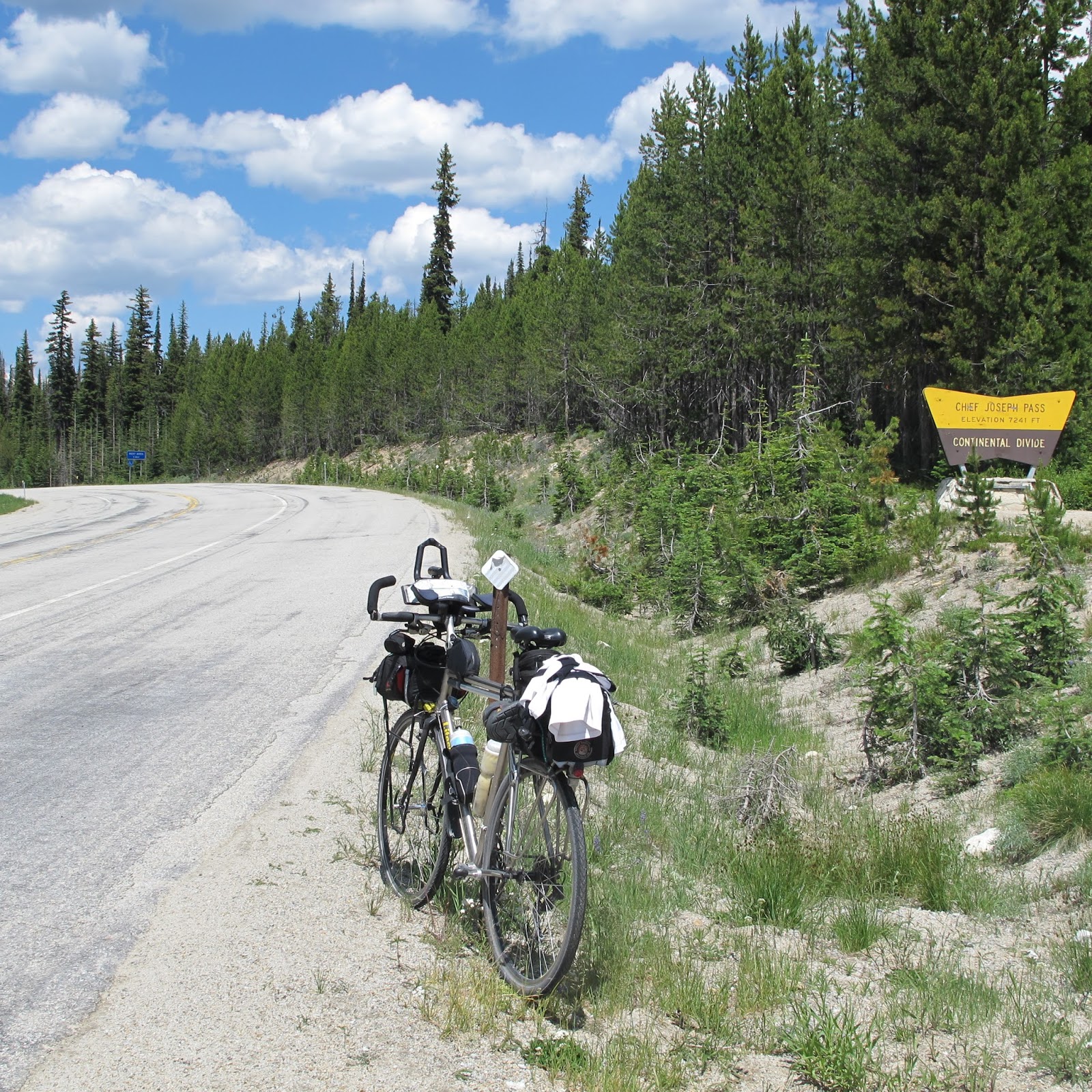
around.  The Chief Joseph Pass (7,264') climb from the open Big Hole valley out of Wisdom followed this pattern of an evolving landscape, rising gently at first, steeply toward the end.


I can hear you, but can't see you Mr. Screech Owl
Why is there so much cowshit on the road?**
Sound of rushing water - climbing, rising and fading away
That ditch has water flowing - what collects there? Oh, there is not much shoulder - have to hold the line.
Car coming - I spy you in my tiny mirror.  staaaaay wide - righto!
A bit of a blind inside curve - need to pedal harder to get around to be visible. Oh, but . . .
Have I really climbed this high already?


And perhaps the most daunting climb was the final major climb, the Skalkaho Pass (7,260'), following the Skalkaho River to its source - a waterfall - high up a winding steeply sided canyon road, itself largely unpaved and single lane with no guardrails, stunning for the evolving views, and its ability to hug the steep canyonsides.


The light - the light is perfect, casting a bright spot on the forest floor
Look at those wildflowers.
Awww, look at that fawn staring me down.
Should I stop to get a picture?
Whoa, steep ravine off the side - watch your line, no railing
Doppler effect of a small spring cascading down the mountain side.
Wind in the pines, whisper as soft as the bed of needles
Creaky trees - catch that fragrance!

Oh, the reward is now given!  How quickly will we fall back down the hill?  The next valley opens up before me. Feel that speed rising with no effort, the wind washing my face faster and faster, my legs ceasing to pedal, just coasting to enjoy.


Oh, look at that view, had I climbed that high?
Nicccceeeeee!  Grip tighter.  Glance at speedometer, approaching 40
Hold it steady - cars coming down behind.
I do trust my bike at this speed, don't I?  It is rolling nicely . . .
Miles are clicking by -  long descent. Crouch for a few miles per hour more! Stay off the aerobars!
Wow, what a hairpin, lean in - see that road laying out in front of me.
Glide and ride all the way down, slowing now as the road flattens out. Have I shifted gears?

Only to do it again . . .


*Granny refers to the lowest gear available to ease climbing, after which there are none lower, literally and painfully obvious!
** The reason? The roads and shoulders are used to drive cattle to different ranges, witnessed several times.  The result is, well, obvious!