August 17th to August 22nd, 2017
No, this is not the Civil War, or some worthless
best-meets-best in a sporting event, I am writing of the stark and not so stark
differences between the northern half of Nova Scotia, toured in 2013, and my
present journey, just completed over the southern half of this great
province. I just could not help
comparing the differences with every peninsula circled, every bay glimpsed,
every wharf visited.
But first some trip details.
Landed in Halifax on Thursday August 17, without my bike. Turns out it preferred the flight following my
arrival, which delayed my bike setup and departure by several hours. I was finally rolling to Peggy's Cove, some 35
miles away, having found my way out of Halifax in heavy rush hour traffic,
travelling with the usual first day jitter-speed, chased as well by heavy
traffic and no shoulder. That is one thing not different about north and south – with rare exception, there are no shoulders
in Nova Scotia. Landed as desired in a
“campground” – a euphemism for a parking lot for RV’s with maybe a few tent
sites – in this case the tent sites fronting the water (so the RV's could look over us tenter's).
As I arrived late, not much time
or daylight to enjoy it, and dashed off to sleep before I could even appreciate the stars.
 |
| My campsite at dawn - you can't see the RV's looking over me! |
This was followed by a long day down along the east coast to
Lunenburg, an absolutely enchanting town, built by German and Swiss boat builders and of
course fishermen. The entire City is a
UNESCO World Heritage site as one of the few remaining planned British colonies still intact. But as my day was
spent along heavy trafficked no-shoulder roads (again), I spun off on a few
rails-to-trails segments until these too evaporated into well-rutted ATV
trails, not suitable for my level of interest or endurance to sustain the
aggravation. As I expected to find a
campsite somewhere in the municipally sponsored site (also an RV parking lot), I was advised they were
quite full, and could not accommodate, but instead directed me to Donna at the
Lunenburg Inn B&B, who had a single room left. She was a wonderful hostess in a wonderful
old mansion, followed by an equally great meal of fish and salad in the Knot Pub, conversing with a local couple providing bits about the City.
 |
| A particularly striking widows walk |
On the subject of fishing villages, another comparison is in
order. The south has them – lots of
them - with colorful fishing boats of all
sizes, seemingly in every little town. Yes, the north has fishing villages, but my
recollection is one of many fewer boats, and not just a few empty wharves
entirely, beyond the rusting relic listing on its side on shore. I know the north was decimated by the cod
fishing decline, and the south is heavily into lobster. And with lobster comes
a wealthier, more thriving sense of place than the north, whose general
dereliction and sometimes poverty was striking. Rarely did one see a boat building enterprise in the North, yet I saw many boat builder facilities in the south, small to large, often with the hulls protruding from the limits of the structures containing them.
 |
| A typical harbor scene repeated over and over, this in Digby |
The next morning, Saturday August 19
th, I was
greeted by rain and wind – a true Nor’easter.
Donna did not believe that I would actually ride in this weather, and
offered me another night. But, I have a
schedule to keep – seeing grandkids at the end of the line! Perhaps I might have taken her up, for I
spent 78 wet miles in the saddle, fighting hills, headwinds and near constant
rain. And in this stretch, the first
similarity between north and south: "nothing". The towns stretching along the
peninsulas I circumnavigated were merely a collection of very small fishing
villages – a few houses and a wharf, and piles of lobster traps. I had my first
ferry ride to LaHave, wherein a fine
bakery existed from which a sweet and
lunch for down the road was had.
 |
| Typical coastal scene |
Though
wet and tired, I did manage to make it to
Thomas Raddall Provincial Park, a
quite lovely park on the water where I had a walk-in site, pretty much to
myself. The rain abated long enough to
set up camp quickly for it shortly continued to rain all night. Luckily, they had an enclosed group shelter
with a wood stove going that I could wait out the evening.
 |
| Thomas Raddall PP and the Nor'easter |
The morning of the 20th was wet but not raining at least, a day that eventually changed over to welcome sunshine and warmth.
I was required to pass along Rte 103 – the heavy arterial which I was
not looking forward to, but for the relatively short distance on a Sunday
morning, it was not as bad as expected. This
day included an excellent stretch of road circling several peninsulas, including the
Lockport peninsula, quite scenic and with low population and traffic. Also passed through Shelburne, a "Loyalist" town, the first to profess their staunch British heritage, founded during the
American Revolution by British ex-pats, called Loyalists.
 |
Typical estuary scene, where fresh water meets salt water
|
But
also of interest, a few miles away, was
Birchtown, a black Loyalist
community of former slaves given their freedom by the British, and counted in
the “Slave Book” by both the British and Americans (monitored by Alexander Hamilton), all on exhibit at a small but
striking museum on the site of Birchtown.
Sadly, many freed slaves, unaccustomed to the weather of Nova Scotia, were
scammed into returning to Freetown in Sierra Leone, Africa, to set up their own country, and
for many, only to have arrived to be sold into slavery again. (Interestingly, this "solution" was also proferred by several of our famous founding fathers during the constitutional convention).
 |
Floor display in the Birchtown Museum
on Black Immigration |
After 82 miles, arriving in
Barrington Passage a bit hot and
tired, the self-proclaimed Lobster capital of the world, I did treat myself to
my first whole lobster, including sheepishly asking for “lessons” on how to eat
it from my server. Well worth the days
work.
 |
| Poor fella - tasted so good! |
Rounding the southeast corner of Nova Scotia on the 21st, I had to
spin out around Cape Sable island, this, a place called
The Hawk, is the southernmost
accessible spot in Nova Scotia. Defined
by a long, flat expanse of cobbly beach and inland marshes with few trees, the
Cape Sable lighthouse in the distance stands like a sentinel in the flat and
barren expanse. This too is in stark
contrast to the northernmost point in Nova Scotia – Meat Cove – were we camped
– hilly, rocky edges cascading into the sea.
They couldn’t be more different, but in
their own way, both similarly beautiful.
 |
| The Hawk - southernmost point of Nova Scotia |
In turning the corner to head along the south and west shores of Nova Scotia, I also entered a strong Acadian heritage area –
des Cotes acadiennes - so strong nearly everything was in
French with little English either spoken or written. It was like I entered a whole new country,
where names ended in
eau or
eault, and the French flag with the single star –
the symbol of Acadia - proudly displayed everywhere.
According to locals, the entire south and southwest coast has the
largest concentration of French Acadians, unlike the pockets we encountered in
the north that were similarly well defined, but much less in number and population, and often
overshadowed by the similarly situated Celtic and Scottish clans.
It was wonderful to experience this change in culture.
 |
| L'Eglise Sainte-Marie |
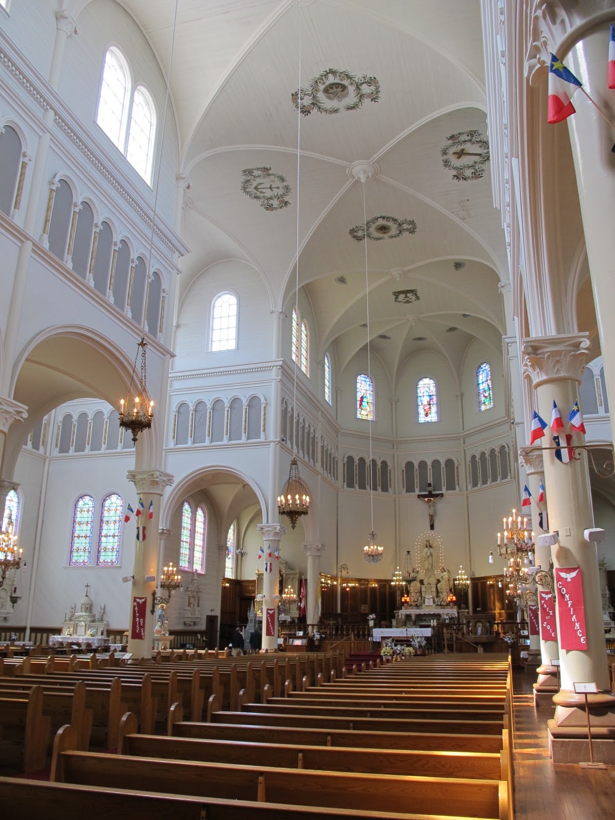
This cultural change was no more manifest than in the magnificence of the churches. Starting in Yarmouth all the way to Digby, the route is known as the Evangeline Trail, for nearly every small fishing village had a magnificent church - and in a few cases - cathedrals. The
L'Eglise Sainte-Marie is the largest all wooden church in North America, where even the central pillars are a single spruce trunk covered in plaster. The
L'Eglise Saint-Bernard is a true cathedral, a gray granite monolith that can be seen for miles around, constructed over a span of 32 years of all granite, by local volunteers. And here the comparison with the north is striking, for the churches were all very simple and much smaller, with the possible exception of Ille Madame, because generally the population is so much less, but the cultural pride just as abundant.
 |
| L'Eglise Sainte-Marie |
 |
| L'Eglise Saint-Bernard |
Completing my southern tour of Nova Scotia with a wonderful spin up the west coast to Digby, I caught the ferry toward St. John, New Brunswick on August 22nd, crossing with much interest the
Bay of Fundy, the place in the world with the highest tidal swings, manifest at this crossing with boat houses sitting atop long stilts over a muddy stretch of beach. This would fascinate me in coming days as I change course and spin down toward Maine and New Hampshire.
 |
| Smuugler's Cove - a 60' deep hidden cave ideal to stash bootleg |
 |
| If the market demands a bigger boat - improvise! |


ReplyDeleteNice article really liked it
plz read also eid al adha wishes 2018
eid al adha wishes for husband 2018
eid al adha wishes for sister 2018
Have a nice day