Sunday, September 18, 2022

The Best, Worst and Final Days

I unwittingly saved the best for last.  And yet, in a way, the last day was both the best and the worst day.

Recall that I had last parted with old friends and gained new friends.  Mariya and I enjoyed four days of riding along the south shore of the St. Lawrence River when she had to backtrack to Montreal to take care of work and personal matters.  I proceeded over the top of the Gaspe Peninsula, itself a broad series of rolling mountain ridges, then gently descended along the Matapedia River to the small town of Matapedia.  I relived a previous trip by camping at the site of a well-known motel where we had stayed and enjoyed a final trip meal.  Instead, this motel, built on stilts along the river, was empty, weedy, and in a state of decay, ironically not from the ravages of economic conditions induced by COVID, but rather a major flood that rose well into the raised first-floor level.  

Hard to imagine this area was entirely flooded part way
up the upper floor.  A deserted 1960's relic, well built.

The present and long-time family owner railed against the ravages of clear-cutting that created the conditions for flooding, which also ruined the prized salmon fishing conditions of the Matapedia.  So camping replaced a room.  The pool was still functional and used by me. It was sad to see and listen to his environmental woes.

Crossing into New Brunswick was like crossing into a new world.  I was expecting that the French language would disappear once departed from Quebec.  Instead, it was as dominant a language as in Quebec for the fact of its ancestry being primarily Acadian. Of French origin, Acadians migrated to the maritime areas of Canada from persecution in France in the 16th and 17th centuries and created a region known as Acadie.  They were later persecuted by the English during its occupation of Canada, and many were deported to Georgia or hid in the more remote regions of the Maritimes.  Most then found their way to Louisiana and began the Cajun clans there that prosper to this day.

The classic New Brunswick coastline.

As I am bicycling through New Brunswick, following the coastline through mostly French-named villages and towns, one cannot help but notice the intense pride and patriotism for the Acadian heritage.  New Brunswick might as well be renamed Acadie for all the signs one could see: painted light poles, flags everywhere, houses dressed in the colors.  

The telephone poles too?

This kind of visual patriotism occurred everywhere!

In the town of Caraquet, I ventured in heavy rain to a Japanese restaurant for a late bite to eat and ended up chatting with a couple, Mario and Barbara, neighbors at the bar.  Solidly Acadian, they explained to me the rich tradition and pride they have and clearly stated that Acadians are not French Canadian as are the Quebecois.  They are Acadian!  I get it.

Mario and Barbara, Acadians, giving me a perspective
of their culture

Just as suddenly, though, I crossed over the long Confederation Bridge onto Prince Edward Island and felt I was immediately tossed into the English countryside.  So much of the landscape, village structures, farm fields, and rolling verdant hills reminded me of places I hiked in England.  

This could be an English landscape on PEI.  The steepness of 
the hills were a surprise.

PEI prides itself on being the birthplace of the Canadian Confederation in 1864, uniting the Province of Canada: Nova Scotia, New Brunswick, Quebec, and Ontario.  It is also famous for its potatoes.  I took a rest day in Charlottetown, a pleasant city with a long history.

The ferry from Wood Island on PEI took me to Nova Scotia, where I encountered more rolling countryside through the town of Antigonish, then traversing the unexpectedly hilly interior toward Cape Breton.  Surprisingly, I found a Warm Showers host in the tiny First Nation village of Paq'tnkek Mi'kmaw, as did another cyclist, Deveenath ("Dave"), a 28-year-old Ottawan of Indian (India) descent who, like me, was crossing Canada on his first trip, starting from Victoria.  We both were well hosted and fed by Jack DeWilde, a Dutchman who married into the Mi'kmaw nation. This was the first time I had ever slept in a recreation vehicle.

Jack prepared a stir fry for Dave and me, accompanied by many stories

Dave and I rode the next day along a hilly Nova Scotia coastline onto Cape Breton Island, then headed north to the town of Whacocomagh, where we camped.  Now it is important to realize that most campgrounds, especially private ones, are geared for recreational vehicles, packed in like sardines, but with a lively social construct of retirees along with some families that park there for extended periods of time.  Luckily, they found a sufficient piece of grass for three tents - the third belonging to Mariya, who decided her one week of vacation was inadequate and joined us via train and taxi from Montreal late this evening to visit Newfoundland.  She arrived as the campground hosted a dance under their expansive shelter, with a live duo playing old rock, country, and some local folk music from nine o'clock until midnight!  The audience was primarily retirees swinging, tapping, and absorbing the tunes of yesteryear.  Quite a sight!  Music is a big deal in the Maritimes.

The dance event at the campground.  Yes, they did start dancing!

We were a threesome now, riding the shoreline of the very long Bras d'Or Lake up to North Sydney, where we caught the 5:30pm ferry to Argentia, Newfoundland.  An overnight ferry, we thus "camped" wherever we could sleep, mostly on the floor between empty rows of seats.  It could have been worse, but for the most part, following a solid breakfast in the cafeteria, we were rested enough to begin the tour of southeastern Newfoundland.  

Aboard the Argentia ferry for Newfoundland

We rarely rode together, but we did travel together!

Shaped like a "W," this route that follows the shoreline is known as the "Irish Loop."  It doesn't just follow the shoreline horizontally but vertically as well, for the landscape is a sculpted rock with fingers that drop precipitously into the sea, villages tucked down and into the coves between these fingers.  And the hills are STEEP!  The villages are small, there are no campgrounds to speak of, and we found ourselves wild camping at a school, a village playground, behind a restaurant, and at a visitors center before finally making it to LaManche Provincial Park.  

An oft-repeated scene - big hills rising out of seaside villages

Many people cannot conceive of wild camping, absent the normal amenities.  In places such as remote Newfoundland villages, it creates opportunities for community interaction, often in very special ways.  Consider the case of Colinet, a small fishing village at the tip of a long bay and a crossroads to points north and west.  Mariya and I arrived late afternoon after 61 cloudy miles to stop at the only store in town - a convenience store with one gas pump, the post office, groceries, and a clerk that knows everybody.  I asked the clerk where we could pitch a tent, and while there was another customer hovering nearby, she engaged her on the question and brought up several ideas when another fellow buying a 12-pack of beer was asked if the playground was mowed.  As he lived next to the playground and mowed it, he affirmed it was, and the discussion ensued among the three of them while Mariya and I just watched this community scene unfold in front of us.  It was settled: "one block down, take a left, go up the hill, and the playground is on the right."

We arrived at the playground a few minutes later and determined it was quite adequate with some picnic tables, a fire ring, fields, and a tired, unused basketball court.  As we started to set up our tents, the beer man came by with his neighbor loaded with an armful of firewood and starter.  We were invited to shower in the beer-man's house and invited to come and enjoy the man-cave environment of the other neighbor, who wished only to be known as "neighbor."  He set up his speakers to blare some music our way.  Dave soon arrived, and we enjoyed a shower, dinner, and a campfire started and tended by Mariya that held off the mosquitoes adequately and the rain affirmatively!  

Our raging campfire.  Mariya loves fires.

Before turning in, we wandered over to the "neighbor" to say thank you for their kind hospitality, but it wasn't that simple.  Another beer was required, and some sit-down and chat time was necessary with the boys in the garage.

The garage gang.

The next morning, stopping a moment at the convenience store, there were three breakfast sandwiches waiting for us, compliments of the owner!


These are a few examples of the complete friendliness of Newfoundlanders, as proud of their Irish heritage as the Acadians are of their French heritage. It is quite random at times.  One couple invited Mariya and me in for tea mid-afternoon while climbing a steep hill, which we graciously accepted (Dave was well behind us).  

The fossil beds
A typical fossil of many types

We visited the UNESCO site at Mistaken Point, the site of the oldest known fossils in the world (530-550 million years old), and the park ranger that helped us get transportation to this site (accessed by reserved guided tour only), who after work, returned to our campsite behind the visitors center with a bag of hand-picked wild blueberries and three homemade blueberry muffins! 

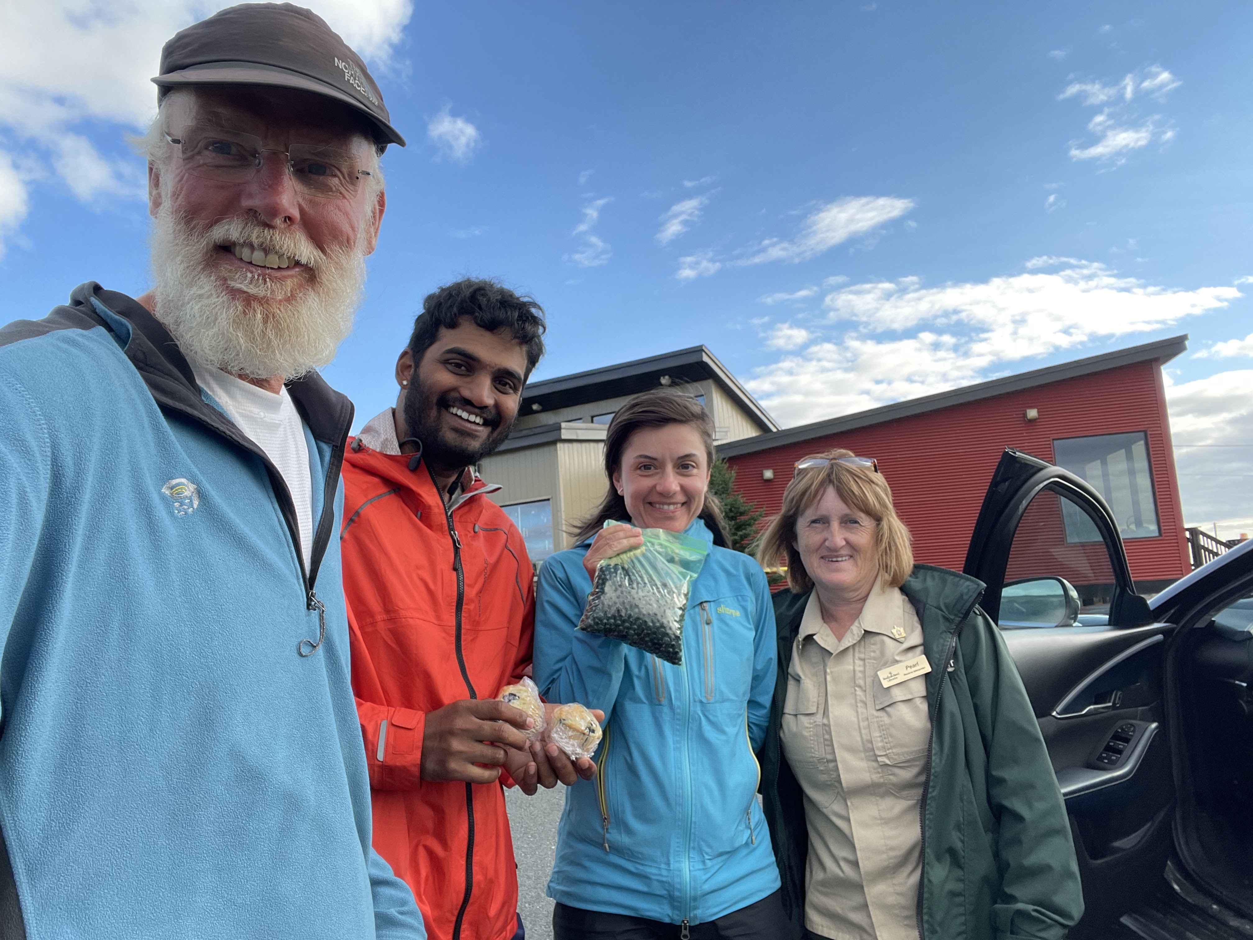
Pearl with her gift of blueberries and muffins!

We visited the ecological reserve and rookery at Cape St. Mary, an astounding place with thousands of birds nesting on a cliff, and a place where the staff was only too willing to help us find the right fleece jacket to buffer against the rising colder temperatures, as there were no other visitors on this cloudy, cold morning.  

The rookery of Gannets on a broken-off cliff  

St. Mary's Ecological Preserve

So by this point, you may ask, "why bad, then?"  Indeed, for it was not the landscape, barren of trees, windswept and hauntingly beautiful.  It wasn't even the hills; though they are steep, we were resigned that they must be overcome and are always followed by some pretty swift downhills.  It was fittingly the last day of riding, the last day of my long journey, the last of 112 days, a day of only 37 miles from LaManche Provincial Park campground (where we camped for free by the good nature of the rangers), the final miles of 5,543 miles.  

This last day proved for me to be the hardest day of the entire journey, for tropical storm Earl was bearing down on the maritime seaboard, and bearing down hard.  Headwinds of over 50 miles per hour in parts, pounding rain mixed at times with stinging sleet, killer hills that never seemed to end, cold, wet hands that could barely shift gears, a roiling seascape, a drenched raincoat, and baggy sodden rainpants.  It was as if Mother Nature was telling me, "you ain't done yet."  These were the most brutal conditions for riding I had experienced, and I was physically exhausted and, worse, mentally drained.  Dave had gotten stuck in the storm and did not make it to LaManche, and got blown over twice by the wind.  Mariya had far less trouble and seemed, as usual, to climb the hills mostly with little apparent effort (though she admits it was hard).  By the time I reached Cape Spear, the easternmost point of North America and my final destination, I had walked up several hills pushing my heavy bike, cursing up a storm, and even had to walk my bike on gentle slopes to avoid being blown over.

Hanging onto my bike at Cape Spear, wet and cold.

It was very, very hard.  Add to that the realization that my trip was 100 meters from being over. I was greeted by Mariya, who preceded me to the top with a hug as I could not help being overcome by emotion at this moment.  I was grateful she was there.  And yet, it was still not bad enough to open Megan's card. (see earlier blogpost).  That was reserved for my return, opened in front of Megan.

It was the end of her trip as well.  I couldn't even take the picture!

Mariya and I pulled each other through this journey when we were together.  And given the conditions, I could spend only a few minutes capturing a photograph and reflecting on my achievement of a lifetime.  A fitting end, perhaps. No long good-bye's!

Trip over.  We got a cab to take us to St. John's to escape the nasty conditions and spent a few days being ordinary tourists, packing our bikes into boxes for travel, walking Signal Hill in the fog, watching the weather change, and reuniting with Dave a day later for a well-deserved celebration dinner.

Mariya loved picking blueberries. 
I loved that she picked blueberries and shared them!


We cheered news of Dave's arrival at Cape Spear


St. John's - the end of the road for our journey together.
I was pleased to finish in the company of new friends!

I take nothing away from the entirety of Canada - its people and its landscapes.  I love Canada.  It is a great place to tour, with great friendly people, and there are many spots as yet unseen that may call to me in the future.  We agreed that the one thing that makes a TransCanada journey so interesting is the people.  That said, we all agreed at this final moment of togetherness that Newfoundland is the friendliest place in Canada, a simple, down-to-earth welcoming place that beckons us for all its severity of landform.


Saturday, August 27, 2022

Old Friends. New Friends.

In many respects the St. Lawrence River is an old friend as I have visited it on a few trips and am fond of its character. For ten days and 656 miles, I was carried by its current from the narrow headwaters at Kingston, Ontario, through Montreal, Quebec (city), and along the south shore to the small towns of Sainte-Flavie and Mont-Jolie, where I parted with my old friend the river, turning south toward New Brunswick across the top of the Gaspe Peninsula.

New friends dominated this stretch of road though I had to say goodbye to old friends on this stretch, and it was hard to do. Permit me to explain.

Route 138 from Montreal into Quebec (city) follows the Chemin du Roy (Kings Road).  Wonderfully scenic and rolling, it is also subject to weather and chance encounters.  I arrived at the small village of Sainte Anne de-la-Perade from Trois Rivieres, having pushed a headwind out of my way.  I stopped and parked my bicycle against a sign pedestal and sat down, scrolling through Googlemaps to see what was available for lodging, camping or a motel/auberge.  There coincidentally appeared a car that parked next to me. A woman hopped out and asked me, initially in French, if I had a place to stay. Of course, I did not as I was searching for just such a spot.  She explained that she had friends that did extensive bicycle travel and had told her that what cyclists need most is a place to sleep and get cleaned up – essentially a warm shower concept.  I graciously accepted her offer. 

Meet Nancy Fraser, 44 and an activities coordinator for the elderly, who invited me to stay at her apartment only a few kilometers away.  I very graciously accepted, got directions, and wound my way through the village to the duplex along the river. We had a wonderful visit.  A beer in a chair along the riverbank, visited and poked at by the local duck.  A simple meal of tomato sandwiches, talked music (jazz), and also played a game of Scrabble.  Though French-speaking, she played in English, and after my strong start, she demolished me!  The next morning a simple breakfast was followed by discussion about, and examination of, her bicycle and how she could get a better fit. 

Nancy Fraser, quick with a beer by the river.

The persistent duck

Losing badly at Scrabble. I will not divulge the score.

A new friend made. After she gave me some homemade beet salad for my lunch, I headed out in a misty gray morning toward Quebec (city). 

It wasn’t long before I had to put on my raincoat to ward off the wetness, for it lasted quite a long time.  Took a short break for a patisserie in Deschambault, a nice village with a dominating church.  I met several other long-distance cyclists there, also on break. The rain took a short break, long enough for me to have lunch at the start of the Corridor du Littoral into the City, a pathway that takes one closer to the river levels through lovely rural areas directly into the old quarter.  That is until road construction (more specifically a closed road) takes you up very steep bluffs, and when closer to the city, the need to surmount the bluffs that provided the city its unique vantage point for protection in the 1600’s.  After walking up several hills and navigating the city streets (also under construction) I finally found my accommodation at Rosie’s Cottage, which is actually not a cottage but a three-story walk-up townhouse in the St. Jean Baptiste neighborhood.  

Rosie's "Cottage"

Rosie is a character, provided all kinds of great information, and the history of her ownership of this small accommodation near the old town area.  It was a wonderful respite from the rain, and reasonably affordable given the tourist-driven inflation generally.

One of several gates into the old quarter


Wandering the wet streets in search of food, and photos

Night shot near Rosie's neighborhood

But I was worried about another old friend as I wandered the damp streets of old town that evening, navigating the crowds and searching for decent dinner fare.


My sandals, quite damp not only on this day, but on this trip, were displaying significant wear and tear, with the emphasis on the latter.  I already had a strap break requiring repair in Victoria, but now another strap pulled out, and the strain on the wet leather-like material seemed risky given the time I have remaining.  It was going to be difficult to replace them anywhere but a larger city.  Many bicycle shops simply do not carry any shoe inventory.  Prior to departing Quebec, I got a referral to Mathieu Performance bike shop and decided to see what they would have.  I was greeted by Pierre and his associate, who directed me to the recommended touring shoe, as that is what he wears. A fit was made, the clip installed, and a final goodbye made as they were somewhat unceremoniously dumped by the associate into the trash.  I did not have the heart (or sole) to toss them myself.

I couldn't inter my beloved sandals, so the associate
took on the task!

These sandals, my old friend, have been on many trips, serving me well every time and everywhere.  I was really very sorry to see them go.  Time to get used to a new friend.

Time to break in the new pair (friend)1

I left the bike shop on the near north side of the city and rode around to the ferry terminal that would take me to the south shore in Levis.  The new shoes, a bit stiff and unyielding, nevertheless began their journey.  It was time to head out along the river.

The ferry departing Quebec for Levis, a view of the old quarter

The ferry is a short hop, maybe 15 minutes across the water, with typically many bicycles on board, just enough time to snap some photos of the receding skyline of old town.  And like lemmings, the bicyclists depart the ferry first in a drove, and I followed to the bike path that headed eastward.  As I did so, I noted another touring cyclist right behind me heading in the same direction.  I slowed a bit to inquire the usual questions of start and destination.  The answer lasted  4 days.

Correcting our "mistake" Mariya and I crossed through beautiful
rural valleys back toward the river.

Meet Mariya Moneva, a 44-year young producer/performance manager for the arts from Bulgaria but living in Montreal, on a short weeklong trek downstream on the same route and destination as I was planning.  We started chatting the typical introductory questions of profession, family, bicycling, etc., so engrossed in the conversation and assuming the other knew which path to take, that we both missed the turn and headed due south instead of east along the river – for about 18 miles!  Time to plot a new course.

Looks like I am struggling to keep up. She tested me
and kept me going!  We were equals physically.

Sunsets were our time to reflect, here along the St. Lawrence at
SEBKA, an environmentally focused campground.  The skeeters
were horrible.

Here's why: one usually meets a lot of travelers while on tour, but most of the interactions are short lived, maybe a few days at the most, with the singular objective of going one’s own way.  It’s only natural.  You make a plan and work the plan.  But this was distinctly different.  Mariya, as it turns out, was hoping for company on this trip but could not find anyone to accompany her, and decided to go it alone to get away from her busy schedule.  On the other hand, I had been traveling solo for 86 days and was quite used to going it alone.  The walk in the old City the evening before was nice, with many pictures taken, but being in a magical place like the old walled city of Quebec is best a shared experience.  I could not do so, the food I found was not that good, the pub too loud and not the intimate setting I had hoped for, and I was in a bit of a sour mood thereafter.  Perhaps, having a shared ride with a stranger was OK for a few miles.

Patisserie.  Boulangerie.  No matter!  She guards
her croissant well!

I could recite all that we discussed but that would be boring.  Suffice it to say that we hit it off as a pair of travelers unusually well.  We rode at a brisk pace together.  We were open to discussing alternative routes and taking them. We were OK with our mistake, and those more minor ones that followed.  We shared our food.  We both enjoyed ice cream and pastries.  We both enjoyed camping, and since she traveled extensively for her job, she actually preferred camping to motels. We walked the beachfront.  We appreciated a shower and sunsets, and engaging with other campers. We talked a lot in front of an evening campfire that she liked to make.  We even agreed upon what we should buy at the grocery store to share. 


The sunsets were amazing, this at a campground in Montmagny

Mariya is the kind of riding partner one could only hope for.  Though she could easily whip me up the hills, and set a crisp pace that would challenge most, I was up for the challenge and rose to it, though there were more than a few hills that I had to walk, and a lesser amount she had to.  Even after a grueling stretch of ridiculously steep grades on gravel that resulted in a long lunch stop, including a nap on the picnic bench, we ended the day, and our trip, in Parc Bic, short in total daily mileage but long on an amazing walk along Ha-Ha Cove in the evening.     


Contemplating the evening in Ha-Ha Baie in Parc Bic.  An amazing
spot and an amazing evening walk.


We celebrated our time together with spaghetti, smoked
salmon and avocado - and a campfire. She enjoyed
my camp chair!

Though tempted to continue one-way with me to Moncton or some other town where she could catch a bus or train home, in the end, the call of duty to take care of business at home turned her bike westward as I headed eastward after 4 wonderful days together.  We continue to follow each other’s journey, and who knows if there is not another planned journey in our future. This was a fleeting capture moment.

She’s a friend, a new friend, and I now believe our wrong turn was the right turn. 


I did struggle on some hills!


Monday, August 15, 2022

Rock, Wind, Water and Apple Fritters

I love apple fritters, yet really good ones - moist, sweet, tender, fresh and appley - are hard to find.

As this post is written, I am well along the St. Lawrence River, having arrived in Montreal for a few day's rest, yet can reflect on the pull of the Great Lakes: Superior that I previously circumnavigated, Huron than I never previously visited, and finally Lake Ontario that ultimately feeds this great St. Lawrence River.  The geography around these lakes is so different from all the geography I have already experienced; a hilly terrain writ from the grinding of the glaciers on incredibly resistant rock, exposing domes and cliffs amid thinly soiled cover of spruce and maple forests, sanded smooth as the glaciers retreated.  It is magnificent.  The sheer power of the great lakes is awesome; inland seas that do not harbor a briny salty aroma and whose waters are very clear and cold.  The north shore of Lake Superior, the largest freshwater lake in the world as measured by surface area, is sparsely populated, with the TransCanada Highway 17 first connecting all the shore villages as recently as early 1960. 

The bay at Neys Provincial Park, as seen from the highway overlook.
This is typical terrain of the superior north shoreline

One of the more interesting places along the north shore is Neys Provincial Park, not merely for its intense beauty and wave-song along a sandy cove beach but for its history.  Neys is the site of a former German prisoner of war camp, primarily for officers, as it was so remote, with no road access and only accessible by boat.  The boats used by the prisoners for fishing and logging are still on a rocky outcropping.  Apparently, many of the prisoners never went home but rather stayed in Canada, and indeed the area, after the war.  Luckily for me, they did have a campsite available following a very hilly 51-mile ride from Schreiber.  

The old boats at Neys, ever so slowly returning to the Lake.

While sitting on the rocks, watching the tide rolling over,
I thought I could gather diamonds!

The cliffs at Old Woman Bay,
Lake Superior Provincial Park

Lake Huron has always intrigued me as it appears on the map to be a bit fuzzy in terms of boundaries.  At the same elevation as Lake Michigan, it is connected via the Strait of Mackinac.  The perimeter of Huron and its many islands is a fuzzy profile that creates almost 2,000 miles of shoreline.  Manitoulin Island is "technically" connected by a short bridge to the "fuzzy" north shore at Little Current due the network of islands, bays and peninsulas that make up the north shore. The Bruce Peninsula connects to Ontario at Owen Sound, and separates the vast Georgian Bay to the east from the rest of Huron.  These features create an extensive shoreline, much of it rocky as if the glaciers left their claw-like marks.  Yet the terrain is relatively gentle with both agricultural and sub-alpine forested areas. The lengthy, often sandy shoreline makes Huron a favorite of the cabin crowd as well as towns that appear to be relatively affluent, at least to this casual observer. 

Crossing the Spanish River at Massey, one of the tributary
rivers from hundreds of lakes on the northern boundary
 feeding Lake Huron
 
The power of these great lakes was revealed to me when I boarded the ferry crossing the strait at South Baymouth for Tobermory at the northern tip of the Bruce peninsula.  A cloudy, windy, and rainy morning greeted me in my campground after a wet night in a tipi as I rode 8 miles into a headwind to reach the terminal.  The waves on the lake were fierce, yet the ferry, named the Chi-Cheemaun, made its way to the dock. 
Awaiting the arrival of the ferry to Tobermory

I was the first to board for the 90-minute crossing, a wild ride that caused the boat to pitch and dip, with spray flying over the bow.  The consideration of a cabbage roll for lunch from the dining area was declined as my risk level for actually keeping it down was not worth testing as I witnessed many people releasing their “discomfort” overboard or into bags provided by staff.  It was the roughest crossing in a ferry I have ever had, and this on a lake rather than the open sea – that is what is so remarkable to me.

A single picture does not convey the true roughness of the lake,
but the angle of the railing to the horizon gives a good indication
of the boat's pitch, as does the flag.

By this point in my narrative you are likely wondering what this has to do with an apple fritter.  Like dough binding apple to sweetness, permit me to explain that it is not merely geography that linked me from Superior to the Bruce Peninsula in Huron, but an apple fritter.  

There is a spot on the northeastern shore of Lake Superior called Batchawana Bay with a store that had promoted itself miles ahead as "famous" for its apple fritters.  I have a soft spot in my gut for these sugar bombs and naturally had to confirm their boast.  I parked my bike near a family sitting at a picnic table and asked them if their fritters were worth it – "definitely" was their response. I walked into the cramped store looking for a bakery case with the fritters and instead found a significant area of wall shelving loaded with small brown paper bags stuffed with a monstrous, dark, aromatic, warm confection.  Returning to my bike, the conversation ensued with the mom asking where I was headed.  After some discussion, they mentioned I was heading in the direction where they live on the Bruce Peninsula called Lions Head.  The mom offered that I could stay with them for a night, apologetic for their small house.  I thanked them for the offer and, on a whim, not knowing my future plans or timing that precisely, asked her to write down her contact information, and I would let her know.  

Five days later, following this wild ferry ride and then beating a nasty headwind south from Tobermory in the rain (not realizing that this big weather system also included several tornado warnings), I arrived at the home of Muffy and Zane and their two children Zev (5) and Roz (3), indeed a small but cozy home in the woods, with chickens, rabbits, a garden and the most interesting, full-sized canoe as a mantle in their living room.  

Muffy, holding Roz, with Zev on the tractor

They operate a guiding service, and Zane was away consulting on trail construction. I was both entertained and entertaining the children and enjoyed a steak dinner, great conversation, a shower, and a sofa to crash on.  The relief from the rain was palpable, and the next morning the skies cleared as I was escorted to the end of the driveway by Zev on his bicycle.

One of my favorite pictures, taken by Muffy, with Zev
seeing me off.  He was thinking seriously about which
direction I should head!

The remainder of the great lakes tour along the shoreline of Lake Ontario was relatively easy riding, quite scenic, and revealed to me for the first time the English heritage of Ontario in a major way.  Starting in Owen Sound at the south end of Huron to Kingston on the east end, where the lake drains into the St. Lawrence, the architecture was distinctly of English heritage.  

This plain, rectangular plan with the center gable 
is repeated everywhere with only slight modifications,
reminiscent and likely informed by English gothic designs

The brick farm cottages of a common design, the town structures crowding the narrow, crooked streets, and the orientation of the villages to the lake as the primary transportation link back in the day made me feel like I was back in England.  It was a sudden and stark reminder of the history of English settlement in this part of Canada when I arrived and slowly rode and walked the sidewalks in the town of Cobourg, founded in the late 1700's by English Loyalists. 

Former Cobourg City Hall, now an Art Gallery
could be in England

King Street in Cobourg 

Serious discussion about bicycle travel with Jill at the
Hello Cobourg Cafe, though the serious expression momentary.

I stopped for lunch at a sidewalk café and was quickly joined for lunch and casual conversation by Jill, herself riding a folding bicycle and living in the town, who had many questions about me, my trip, and preparations thereon.  A fleeting moment captured; I was all smiles that day.

So, the moral of this story is always stop for apple fritters! 

Sunday, August 7, 2022

Megan's Card

The adage that one should take the road less traveled by does often apply to bicycle touring.  Indeed, I have had days where I have taken that less traveled path and have been repaid with splendid rural scenery, the call of birds, excellent vistas, and peeks into farmsteads and fields.

Today started out that way but ended quite differently.

With the excellent directions provided by my Warmshowers host Connie in Collingwood, I started yesterday on the Collingwood Train Trail, a well-graded pathway for some distance, and ended a long, interesting ride at one of many locks that connect the various lakes in this region north and northeast of Toronto.  Many less traveled roads on this route, with plenty of climbing that is customary with less traveled, meaning less engineered, roadways.  The notion that a straight line on a map might indicate a reasonably level, perhaps slightly rolling terrain is not to be trusted.  We know that what goes up must come down and can look forward to that free spin.  

Typical rolling hills of this area north of Toronto

The long 75-mile day ended camping for free at the Trent-Severn Lock in Kirkwood, Ontario.


Today, I hoped for the same magic.  I selected a route that indeed took me through some excellent country on very low-traveled rural roads, even gravel, to Lindsay, a larger river town with an excellent character as judged by the downtown architecture, with much commercial enterprise active even on this Sunday morning. 

Even some of the rural gravel roads are quite passable
even creating a wonderful "tunnel of trees."

From Lindsay, I planned to get onto the Victoria Rail Trail.  From my research on their website, it was noted that a section of this lengthy trail well north of my intended route was less suitable for bicycling due to heavy ATV use.  I connected with a pleasant paved section in town that changed to smoothly graded and entertained the hope that this trail would be OK. 

It was not.  It soon became a rutted, cobbly route that had way too much ATV traffic on it. I clearly do not have a “gravel bike” that such riders would welcome this kind of challenge.  But with my gear and having been passed by three ATVs in a short, dusty stretch, I was angry.  I had to walk.  I was far enough not to turn back, so I connected with the next possible roadway, Highway 7, the TransCanada Highway, that I thought I had left permanently behind.  Nuts!  I thought that since I traveled it for so long before now, I would just get on and go, and connect with another promising rural route ahead.

I can tolerate Highway 7 if the drivers can show tolerance for me.  The traffic was quite heavy for a Sunday, though not many big trucks. But today, something just got to me, besides the rising heat.  The drivers seemed not to give me the space, squeezing by too closely for my comfort, wave after wave of cars.  A truck came up and seemed to own the road and, rather than slowing, honked for me to get out of the way.

I was done!  With a full-throated expletive yelled, not so much at the truck but at the situation, I turned off the next sideroad and decided I would figure out a different route.  I turned onto the paved Heights Road (not a good omen) and then onto Mt Horeb Road (another bad omen).  At least these were low traveled.  The Hogback Road veered off of Mt Horeb Road and reconnected with Highway 38 farther south, connecting me in the direction I wanted toward the Lake Ontario north coast.  Ominously, there was a small, yellow “not maintained” sign as I headed down a very steep hill, initially OK in terms of condition.  I had to travel some gravel roads before and tolerate them. Obviously, this too, was more of an ATV path, and I just resigned myself to the notion I would just have to walk up this cobbly road until I had a better condition to work with as I did not have to go too far.  Thinking I could have stayed on the Victoria Rail Trail and walked, I was committed now and was more than halfway to Highway 38 when the road veered sharply left off the ridge (the hogback) and back steeply down into the valley.

Walkable, the Hogback was a cobbled challenge!

The problem was this road virtually disappeared in the valley, having been torn up by deep ATV ruts.  I was now closer to the highway, and the notion of turning around persisted, but I thought I could push my bike through this mess and come to better ground ahead.  Instead, I pushed through mud, thickets, ruts, around and through downed trees, all the while being swarmed by mosquitoes.

There is, or rather perhaps was, a road here.
The darkspot is one of several mudholes.

Fully angry with myself at my stupid decision to ignore the little yellow “not maintained” sign, I was stuck and at wit's end, with the Highway audible – so close, yet so far.  It was so bad that not even ATVs had created a path in this last quarter-mile section.   Words cannot properly express the disaster of this situation.

Permit me to divert.  Megan Seltz, my friend and erstwhile University colleague who has supported me on this journey and manages the fundraising website, gave me a card before I left that was to be “opened on a bad day.”  Sitting in that wet, woody mess, attacked by hundreds of mosquitos, I thought maybe this was such a bad day to open the card.

Hell no!  I got myself in this mess; I would need to get myself out of this mess.  I decided to scout and bushwhack the path ahead and portage my bike and panniers separately.  Gradually, with the Highway noise getting closer, I made a final rise up a semblance of a rocky pathway to the Highway. My bike was covered in mud, with the mud compacted between my fender and tires to the point they would not roll forward.  Glad to be on the Highway, I took sticks to clean as much mud off the bike and my sandals (yes, sandals!).  I could not use any water from my bottles as it was getting low.  The sun was bearing down, and the heat was building. 

Having lost so much time (perhaps 2+ hours?) on this epic detour, I again rerouted, knowing I would not make my initial target of Cobourg, and instead turned my sights east to the larger town of Peterborough, with a direct road – Hayes Line – straight across to downtown Peterborough. After preparing my bike to travel again as best as possible, I rode the short distance to Hayes Line and turned up it, with the definitive emphasis on “up.”  It was a monstrously steep and long hill that I simply did not have the capability or will to cycle up.  So off again, and push.

Many folks think pushing a bike is kind of wimpy.  I will tell you it is not, that it is actually harder to push a bike uphill fully loaded (and muddy) and can be quite exhausting.  I did finally crest the hill and turned into the first driveway I could find.  I parked my bike against a propane tank and knocked on the door.  A man eventually answered, and I was given permission to use his hose, conveniently near his front door.  I sprayed everything down – my bike, my panniers, and me.  I can say that I did provide his somewhat parched lawn with an excellent topsoil amendment.

I rolled back onto Hayes Line, now with a monstrous downhill where even I had to use my brakes.  And then another uphill, and another, and another.  While I did have the benefit of a warm tailwind, it did little to help me push my bike up these continuous roller coaster hills.  This was probably the worst set of continuous roller coaster riding I have ever done, and it was exhausting.  Finally, I crested a hill on the western edge of Peterborough, and as I started to coast downhill, a man selling corn out of his driveway called out to me and wanted to talk.  I did not mind stopping to chat as I was gassed.  I believe his name was Sean – we’ll go with that.  

Sean and his corn stand, with stories to tell.  He donates 
all he earns with corn and pumpkins to a men's shelter.

He invited me into his home and gave me ice and water, and we chatted for about 20 minutes.  Sean was on disability and wanted to talk to me because a bicycle accident put him there on this same hill I was descending.  At this moment, another customer stopped for corn.  I told Sean I needed to get going as it was approaching 6:00 PM.  Sean was anxious to tell this drive-by customer that I was biking across Canada (much to my embarrassment).  His wife and child were waiting in the car and soon departed with good wishes for my journey and their dozen ears of corn.

I thanked Sean profusely for the ice and water and coasted downtown, heading for the main street, George Street North, as there were two possible hotel options.  As I approached a traffic signal in my bike lane, gazing at the wonderfully preserved buildings, out pops the customer from the corn stand – Caleb – from an Indian restaurant, asking if I had eaten (I had not) and to please come join them as their guest.  I accepted, knowing that spicy Indian food would be good, the invitation sounded pleasant enough, that it was dinner time, and they were kind folks.

Caleb, holding Elijah, and Sarah

Caleb and his wife Sarah run a marketing firm focused on small local businesses together. They have three children and one on the way (two were just taken to summer camp), with Elijah, the three-year-old, joining our table.  Let me just state it was a fine meal, great conversation, and excellent entertainment from the ever-talkative and smiling Elijah, who could see my parked bicycle out the window and kept asking me, “is that your vehicle?” and telling me he loved me!  Sarah went to make a call and soon returned as I needed to get going.  What she had done is call the Peterborough Inn and Suites a few blocks down to not only reserve the room (since she was well familiar with them through her previous work as a tourism coordinator) but to pay for it!

What a gift!  I would call the end of this day yet another tailwind, the driving force of people and donors that pushes me to continue, even against all odds as I had experienced today, even colored by the stupid decisions we regret but can look back on it this way: if this day had not happened as it had, I would not have met Sean, Caleb, Sarah, and little Elijah, and experienced their generous spirit and kindness.   

And Megan’s card remains sealed.

Monday, July 25, 2022

Halfway!

Halfway means completion is possible and no longer daunting.

Halfway is a milestone on any journey, but for me is a bit hard to pinpoint where halfway is, or in fact, was. 

Canada's longitudinal “halfway” point is just east of Winnipeg (day 52).  This is the only reference to halfway that is absolutely certain, for I do not know the final mileage nor the final number of days to reach my goal in St. John’s, Newfoundland.  But let’s assume my trip planning was pretty good at 5,700 miles and 110 days, then day 55 brought me to Fort Francis, opposite International Falls, Minnesota, that is due north of my home in St Paul.  

On the promenade in Fort Francis, with International Falls across the water
Reason to celebrate with ice cream!

If by mileage, then 2,850 miles was achieved on day 60 on the road between Thunder Bay and Sleeping Giant Provincial Park, where some rest days camping with friends may have marked my logical “feels like” halfway point.

The Sleeping Giant, resting in the sunset of the first half of my journey.
Can you see her lying there?

As I write this, I have started across the north shore of Lake Superior and the second half of my journey, realizing that, more than anything else, I can complete this journey! As you know, I have much time to think about things whilst balanced on my wheels, particularly what halfway might really mean for this journey.  Consider:

I just changed my tires in Sleeping Giant, which means this new pair of tires should last the entire journey. (Commercial endorsement: Schwalbe Marathon Plus are the best tires). I have had zero flats thus far.  I hope that incredible record stands in the second half.

Showing blue is the sign of a fully worn tire!

I have passed through three time zones in Fort Francis – Pacific, Mountain, and Central.  Three more to go: Eastern and the two maritime province zones, Atlantic and the half-hour shift in Newfoundland.

Crossing into the eastern time zone, just east of Shebandowan, Ontario.

That once around Superior, I have likely completed well more than half of the vertical gain I can expect on this trip with the Rockies and Cascades, and even the more rolling northern prairies, accounting for the greatest elevation gain behind me.  And of the watersheds, I have completed two out of three watershed passages: Pacific and Arctic, and have passed into the Atlantic watershed for the remainder of the journey, halfway across Canada.  This is amazing to comprehend that the drop of water I experienced in the many rainstorms flowed to the Pacific and the Arctic seas (by way of Hudson's Bay) and now, halfway across, flows all the way to the Atlantic via the Great Lakes and the St. Lawrence River.

Crossing into the Atlantic Watershed halfway across the continent, 
east of Atikokan, Ontario

It is conceivable that I have seen more than half of all the trucks go by that I will see. That is a welcome prospect.  The reason is simple: I have more local road options heading east this second half than the limited TransCanada highway this first half. I welcome that prospect.

The prospect of having eaten only half of all the ice cream I will consume on this journey is a welcome prospect.  The same goes for chocolate milk and orange juice.  As I have not had poutine yet (doesn’t seem the best kind of ride fare), that prospect still looms in the second half. The best seafood is yet to come.

I have been exposed to two languages thus far – English and First Nation tongues.  I have two to go – English and a lot of French.

Though hard to predict, I have only taken half of the photos I can expect to take, including selfies! And speaking of self, I will likely not lose the same amount of weight this second half as the first.  Weight loss on long bicycle trips follows a parabolic curve – the lesser the continuing loss, the longer the journey. But lean is still a prospect. And to think my hair and beard are only half of what they will be - maybe a barber will arrive in the second half; then again, it is curious to see what shaggy really looks like!

At nine Warm Showers hosts, it is possible I will have that many more this next half.  What a joyous prospect to learn about different cultures through this network.  There are many more hosts in the eastern half of Canada than in the western half.   

It is possible that I have many more occasions to answer the question, “where are you headed?”  The population and number of towns and the potential for interaction are much greater in the eastern half of Canada.

Due to that greater population prospect, it is also possible that I have seen more wildlife this first half of the journey than the second half will present.  While I have seen bears (8), elk, deer, bighorn sheep, beaver, and many lesser creatures, I have not seen any moose.  They span the entirety of Canada. I am still hoping to see this beautiful, elusive creature.

This elk must just be posing for the travelers to Jasper

Indeed, marking halfway really means “I can do this!

Can you?  Hopefully, I am only halfway to the number of funds I will raise on this trip.  If you haven't already, please consider donating to any one of the causes around education I am riding for.  Please visit my ride website for more details: https://z.umn.edu/PeterbikesCanada

Tuesday, July 12, 2022

If You Could Read My Mind. . . (while riding)

Many people ask me if I listen to music while I am riding all day.  I do not.

Many people wonder if I get bored when I am riding all day.  Sometimes, yes, but mostly no.

Many people ask me what I think about while I am riding all day.  Not much, but a lot.  

OK, that doesn’t make any sense, but it is true if you think about it.  Riding long distances clears one’s mind of normal day-to-day thinking and the stress associated with that thinking.  It takes a few days, but riding is great therapy for mind-clearing.  What follows is a typical “if you could read my mind” translation, not always in such proper form, however.


What kind of bird was that?  Pretty call.

Truck ahead, check behind.  Ok, no issue. . . brace for windwash!

Shift.  Oh, yes! That’s better . . .

God, what a view!

How did underwear get there?I don't want to know.

Oops. Caterpillar!  Swerve.

Fucking gravel!

Ouch – pinch in left shoulder.  Drop to aerobars.

Thirsty. Take water.  Drink more.

When will this rain stop?

Another bungee cord . . . oh, that’s busted. Already picked one up

Scissors?  How’d that get there?  Stop, let’s see ‘em [small pair, perfect.  Keeper]

Wait, is that a good rag to wipe my chain?

Is that a bear?  Stop. Watch. Cute fella.  Better ride opposite side.  No traffic, cross. Stay there, fella!

Damn, this headwind!  When will I get a break!  Grass still blowing the wrong way.

Another single glove. Coulda had a mismatched pair by now!  Where were they when it was really cold?

I don’t understand people that throw their trash.  Sick!

Poor thing.  Raven.  Common and dominant here. One less.

Fucking cracks!  Annoying!

Am I really going this slowly?

Could that be the summit?  Or a false summit to trick me? Grind on.

Cute town.  Quiet. Actually, a bit desolate.  Really wide streets.  Was it really so you could turn a horse-drawn wagon around?

More shiny grain bins.  Few large terminals.  I suppose they want to control their sale point and maybe their type of crop stored?

Ride the line – it seems smoother.  Steady . . . damn cracks!

Ahh, cherries!

To go: voy, vas, va, vamos, van!  [to go - practicing Spanish verbs on boring stretches]

Ravens, blackbirds, and meadowlarks, oh my!

One red children’s shoe.  Really? “but Mommy I don’t LIKE this shoe!”

That is NOT Lipton’s tea in a bottle.  That’s disgusting. Do they pee while driving the truck, then toss it?

What the heck is THAT?  The big trucks haul big stuff here.  I suppose it is more economical but maybe that is why the shoulders suck.  No idea what that machine is used for. Glad they went a bit wide.

Cut grass there?  Such a big yard in the middle of nowhere, yet it is cut and manicured.  Canadians do like their cut lawns and driveway verges as if to mark their domain in some way.

Who knew canola could be so pretty when booming?


What’ll my next blog be?  Maybe I could write about an open mind, but is it really wide open?

[Repeat from top]