Sunday, September 3, 2017

Favorite Photo's From the Maritimes

Trip over.  816 miles. 13 riding days.  2 countries (but felt like 3 if you include Acadia).  And many an opportunity for photographs along the way.  Hard to pick the top pictures of hundred's taken, but here are some of my favorites (beyond those earlier published):


Geese are common, but rare to see from above, as captured here
from a bridge

So common to see deteriorating boathouses,  this along Rte. 331

The creek finds the sea, as does the fog - together.

Cemeteries were everywhere, overtaken in many cases by natural
forces.

Typical seen on the rocky southwest shore of Nova Scotia,
this a perfect ride morning (Smuggler's Cove on the Evangeline Trail).

Seaweed seems to have two lives - in the water at high tide,
and just hanging there seemingly lifeless at low tide.

Oh, the clouds.  The ferry to Deer Island.

Almost kaleidoscopic, the main vault at St. Bernard's Cathedral 

Herring Cove on Campobello Island - one of my favorite changing
seascapes - this late afternoon as fog mixed with sun and wind.

The same view the next morning.

The rocky Herring Cove beach at sunrise, like stepping on diamonds

The tide recedes leaving reflective pools on Bailey Island

The clouds seemed to swirl around this 1827 day beacon to
seafarer's, with a food cache in the bottom for any shipwrecked sailors.
Little Mark Island, Casco Bay

The ubiquitous lobster trap buoy - everywhere!  A record harvest
expected this year, but how do boats not tangle these up?

Oh, the clouds - again.  Casco Bay.

And of course, lighthouses - lots of them.  This on
Cape Elizabeth - supposedly the most photographed
lighthouse in the country.  I could not resist.
A tidal pool in Kittery - note the snail trail - like my trip!
Lobster boats everywhere, often not in the water, casually resting on
shore in Vogler's Cove.
The bicycle seems to hide among the buoys - a welcome stop for
chocolate milk.  (Deer Island)
Campobello and FDR's "cottage" - the gardens were more interesting
than the house!
The croissant in the landscape - soon departed.  From a bakery in
Upper Tantalon
I usually do not see much wildlife, but this porcupine blocked my way
and I had no interest in testing its nerves.
Seaweed everywhere - rubbery and faintly colorful.

The jetty at Kittery - a study in perspective, and a reminder of the
influence of tides seen during the entire trip.

But the real reason for the bicycle trip - call it an excuse, the fourth time I have done so - is to see the children and grandchildren!

Charlotte, Henry, Heather and Ryan
aboard the ferry at Bar Harbor

Monday, August 28, 2017

Crossing Paths

Oh, the people you meet!

It is always a consequence of travelling solo on a fully loaded bike that conversations are likely to ensue. This trip has been no exception, and so some tales of the people I met along my journey.

I had long been anticipating crossing the Bay of Fundy to St.Johns, New Brunswick.  The Fundy, as it is called here, has one of the highest tide swings in the world.  I arrived at the ferry dock around 4:30 for my 5:30 departure, just as the inbound ferry was arriving.  I parked my bike by a fence as I unpacked some clothes for the chillier transfer as I never like to be inside a ferry, preferring the deck view. I did take note of another passenger being dropped off near my parking spot, overhearing the well wishes of departing friends, and we said hello to each other as she passed by.  Did not take much note of this, as there were lots of people hanging around.  I also spoke at length with another gentleman from Riviere du Loup (on the St. Lawrence, a town I had passed through on my 2013 journey), also a biker with four bikes, comparing notes in broken French/English as best bikers can communicate, he quite jealous of my trip and inspired to visit his son by bike.

The Fundy Rose - awaiting boarding to St. Johns, New Brunswick
Finally boarded the ferry and found my way top starboard side behind the bridge to observe the departure, and hopefully see whales in the Bay during crossing. There weren’t many people up there, but that was fine.  I counted the rungs on a service ladder at 20 from what I could observe to be high tide and a presumed low tide.   That could be easily 20’ of difference.  Finally, we pushed away, my tour of Nova Scotia complete and the next leg to begin.

Boat houses and the tidal swing most evident as we departed

But I was curious.  As we departed I observed the southern tip of the Annapolis peninsula as we were heading out to sea, and one could easily see the tide lines, but was this now low tide?  Or did it go lower still?  I had taken note of the same woman I had seen earlier, standing and contemplating the shoreline as I was doing a bit farther aft.  I was just curious enough that I walked over to her, said hello again, and asked her if she knew this to be low tide, hoping she was a regular, local passenger.  She thought it not actually fully low tide yet, and indeed was from St. Johns, but now embarked on her first ferry passage after having visited with her friend of 30+ years.  And so ensued a conversation with Patty that lasted the entirety of the voyage.  As we had similar interests and past experiences, primarily in the Canadian Rockies, we shared all manner of stories of adventures, especially as we were soon quite fog bound in the middle of the Bay, with no hope of seeing anything, yet in the cool chill we remained on deck, chatting away about kids (her four), careers (hers as a mother having left her older teenage kids for this trip – first time ever), and all manner of other topics that strangers can discuss.

Our view from the Ferry - no whales to spot!

Apparently, the fog in St. Johns is quite common.  Over the course of our conversation, Patty invited me to get a ride across the bridge since bicycles cannot cross, and further extended to an  invitation to stay at her home where she could get me back on the road in the morning.  But with some regret, she thought her kids would not appreciate it, (as she has done so for travelers before much to their chagrin), did not know the state of her house after a week – you get the idea – yet as tempting an offer that was, a hotel seemed best, but I did accept the ride.  St. John’s, when we finally arrived around 7:45 was socked in thick fog and getting dark – the last thing I wanted to do was ride my bike in a strange place, guided only by my GPS, in dark fogginess – that would be a frustrating and dangerous experience I cared not have.  So her son Ben picked us up, we stopped at Tim Horton’s for dinner, and then I was dropped off at a hotel along my way out of town in the morning. With a big hug, Patty departed, both of us richer for the experience.  Thanks for the lift, Patty!  

That fog became mixed with rain overnight, and the weather the next morning was miserable, including a persistent headwind.  But I had a ways to go to get to Campobello Island, on the Canada/Maine border area.  I slogged through three hours on the TransCanada highway - pretty, but not interesting, safe though, with a wide shoulder and rumble strips from which I could hunker against the wind, rain and fog.  And when I finally exited this freeway near St. George, blue sky and sunshine finally broke through, and following a quick lunch, I was again on quiet backroads, enjoying the scenery, and taking two connecting ferries.  The first was to Deer Island, run by the Transportation Department, including a large truck and a few vehicles, an extension of the state road.

Seems impossible that such a rig can work on these small ferries - glad mine fit!


The second privately run ferry, which  I spotted was shortly ready to depart as I rounded a curve, was a diminutive barge-like platform that could at most hold perhaps eight vehicles, but at this moment had only one, and five other bicyclists.  I sped across to reach the ferry just in time, and we departed. I was then chatting with the other bicyclists - whom I shall refer to as the Ferry Five.  All younger, fairly recent college graduates trying to find their way in the world, in some form of career transition from New Orleans, as a group of friends making a round-trip journey from Portland, Maine, around Nova Scotia, now on the return leg. Of course there is lots to talk about, and we covered much in that 30 or so minutes it took to cross the pristine bay to Campobello Island, site of an international park.  I was planning to encamp at Herring Cove but a few miles away (a fabulous spot) as  they were continuing on across the US border to a friends farm down the road, and so we parted ways.

The Ferry Five taking in the whirlpools swirling the sea around us

Following a visit to the "cottage" of Franklin Delano Roosevelt on the island, I crossed the border bridge in Lubec, Maine and headed through some very beautiful backroads, but a genuine roller-coaster of steep hills, causing an acceleration of fatigue, to where I took the chance on a rails-to-trails pathway that would potentially run flatter but be slower due to the gravel surface.  On this trail, I encountered Nathan, who had just this day, August 24th, departed Quoddy Head near Lubec for his transcontinental journey to San Francisco.  He too, was struggling against the gravel surface, and as we were heading to the same Sunset Point campground, we rode the balance of the day together, he suffering his first flat tire in the process.  In the toughest of situations, having company does seem to make the miles melt away a bit faster.  Nathan, a recent college graduate from Hamburg, New York, seemed eager to learn the tricks of a seasoned veteran, and I was happy to provide them, most especially since I found out that he had no food, stove, plate/bowl, fork, spoon or cup, expecting instead to get this along the way.  As there was no food to be had near Addison and our campground, I shared my freeze dried chicken gumbo with him, and in the morning, instant eggs served with a list of suggestions to make his journey more successful.

Nathan pushing down Hwy 1 - and San Francisco!
We did ride the next morning together, had a real breakfast at a local cafe in Milbridge, and followed US 1 until early afternoon, where I would part ways for Bar Harbor, and he would continue on.  As I was approaching my turnoff at West Sullivan, I noted a small food stand along the side of the road on which five rather familiar bicycles were parked.  It was here that I introduced Nathan to the Ferry Five, a reuniting if you will with "Professor", a crossed path once again, where we all shared some ice cream and stories.  Nathan departed on his journey with the best of wishes, and I rode with the Ferry Five near to Bar Harbor, where they were headed to a campground, and where I would cross paths with my sweetheart, Becky, and with Ryan, Heather and the grandkids, Charlotte and Henry for a weekend outing in Acadia National Park.

The Ferry Five + Nathan with the "Professor"
Crossing paths, and the stories they generate, keep me going.  But there were many paths I crossed - the countless cemeteries that dot the villages - whose story was only told in stone.  And of this story, cold and hardened to the truth of the seas that have claimed so many in this region, I could only imagine the toughness of these sailors and fisherman.  My journey is simple compared to theirs . . .


Sunday, August 27, 2017

Nova Scotia: North vs. South


August 17th to August 22nd, 2017

No, this is not the Civil War, or some worthless best-meets-best in a sporting event, I am writing of the stark and not so stark differences between the northern half of Nova Scotia, toured in 2013, and my present journey, just completed over the southern half of this great province.  I just could not help comparing the differences with every peninsula circled, every bay glimpsed, every wharf visited.

But first some trip details.  Landed in Halifax on Thursday August 17, without my bike.  Turns out it preferred the flight following my arrival, which delayed my bike setup and departure by several hours.  I was finally rolling to Peggy's Cove, some 35 miles away, having found my way out of Halifax in heavy rush hour traffic, travelling with the usual first day jitter-speed, chased as well by heavy traffic and no shoulder.  That is one thing not different about north and south – with rare exception, there are no shoulders in Nova Scotia.  Landed as desired in a “campground” – a euphemism for a parking lot for RV’s with maybe a few tent sites – in this case the tent sites fronting the water (so the RV's could look over us tenter's).  As  I arrived late, not much time or daylight to enjoy it, and dashed off to sleep before I could even appreciate the stars.

My campsite at dawn - you can't see the RV's looking over me!
This was followed by a long day down along the east coast to Lunenburg, an absolutely enchanting town, built by German and Swiss boat builders and of course fishermen.  The entire City is a UNESCO World Heritage site as one of the few remaining planned British colonies still intact.  But as my day was spent along heavy trafficked no-shoulder roads (again), I spun off on a few rails-to-trails segments until these too evaporated into well-rutted ATV trails, not suitable for my level of interest or endurance to sustain the aggravation.  As I expected to find a campsite somewhere in the municipally sponsored site (also an RV parking lot), I was advised they were quite full, and could not accommodate, but instead directed me to Donna at the Lunenburg Inn B&B, who had a single room left.  She was a wonderful hostess in a wonderful old mansion, followed by an equally great meal of fish and salad in the Knot Pub, conversing with a local couple providing bits about the City.


A particularly striking widows walk

On the subject of fishing villages, another comparison is in order.  The south has them – lots of them -  with colorful fishing boats of all sizes, seemingly in every little town.  Yes, the north has fishing villages, but my recollection is one of many fewer boats, and not just a few empty wharves entirely, beyond the rusting relic listing on its side on shore.  I know the north was decimated by the cod fishing decline, and the south is heavily into lobster. And with lobster comes a wealthier, more thriving sense of place than the north, whose general dereliction and sometimes poverty was striking.  Rarely did one see a boat building enterprise in the North, yet I saw many boat builder facilities in the south, small to large, often with the hulls protruding from the limits of the structures containing them.
A typical harbor scene repeated over and over, this in Digby

The next morning, Saturday August 19th, I was greeted by rain and wind – a true Nor’easter.  Donna did not believe that I would actually ride in this weather, and offered me another night.  But, I have a schedule to keep – seeing grandkids at the end of the line!  Perhaps I might have taken her up, for I spent 78 wet miles in the saddle, fighting hills, headwinds and near constant rain.  And in this stretch, the first similarity between north and south: "nothing". The towns stretching along the peninsulas I circumnavigated were merely a collection of very small fishing villages – a few houses and a wharf, and piles of lobster traps. I had my first ferry ride to LaHave, wherein a fine bakery existed from which a sweet and lunch for down the road was had.

Typical coastal scene
Though wet and tired, I did manage to make it to Thomas Raddall Provincial Park, a quite lovely park on the water where I had a walk-in site, pretty much to myself.  The rain abated long enough to set up camp quickly for it shortly continued to rain all night.  Luckily, they had an enclosed group shelter with a wood stove going that I could wait out the evening.


Thomas Raddall PP and the Nor'easter

The morning of the 20th was wet but not raining at least, a day that eventually changed over to welcome sunshine and warmth.  I was required to pass along Rte 103 – the heavy arterial which I was not looking forward to, but for the relatively short distance on a Sunday morning, it was not as bad as expected.  This day included an excellent stretch of road circling several peninsulas, including the Lockport peninsula, quite scenic and with low population and traffic.  Also passed through Shelburne, a "Loyalist" town, the first to profess their staunch British heritage, founded during the American Revolution by British ex-pats, called Loyalists. 

Typical estuary scene, where fresh water meets salt water

But also of interest, a few miles away, was Birchtown, a black Loyalist community of former slaves given their freedom by the British, and counted in the “Slave Book” by both the British and Americans (monitored by Alexander Hamilton),  all on exhibit at a small but striking museum on the site of Birchtown.  Sadly, many freed slaves, unaccustomed to the weather of Nova Scotia, were scammed into returning to Freetown in Sierra Leone, Africa, to set up their own country, and for many, only to have arrived to be sold into slavery again.  (Interestingly, this "solution" was also proferred by several of our famous founding fathers during the constitutional convention).

Floor display in the Birchtown Museum
on Black Immigration

After 82 miles, arriving in Barrington Passage a bit hot and tired, the self-proclaimed Lobster capital of the world, I did treat myself to my first whole lobster, including sheepishly asking for “lessons” on how to eat it from my server.  Well worth the days work.


Poor fella - tasted so good!


Rounding the southeast corner of Nova Scotia on the 21st, I had to spin out around Cape Sable island, this, a place called The Hawk, is the southernmost accessible spot in Nova Scotia.  Defined by a long, flat expanse of cobbly beach and inland marshes with few trees, the Cape Sable lighthouse in the distance stands like a sentinel in the flat and barren expanse.  This too is in stark contrast to the northernmost point in Nova Scotia – Meat Cove – were we camped – hilly, rocky edges cascading into the sea.  They couldn’t be more different, but in  their own way, both similarly beautiful.

The Hawk - southernmost point of Nova Scotia

In turning the corner to head along the south and west shores of Nova Scotia, I also entered a strong Acadian heritage area – des Cotes acadiennes - so strong nearly everything was in French with little English either spoken or written.  It was like I entered a whole new country, where names ended in eau or eault, and the French flag with the single star – the symbol of Acadia - proudly displayed everywhere.  According to locals, the entire south and southwest coast has the largest concentration of French Acadians, unlike the pockets we encountered in the north that were similarly well defined, but much less in number and population, and often overshadowed by the similarly situated Celtic and Scottish clans.  It was wonderful to experience this change in culture.


L'Eglise Sainte-Marie
This cultural change was no more manifest than in the magnificence of the churches.  Starting in Yarmouth all the way to Digby, the route is known as the Evangeline Trail, for nearly every small fishing village had a magnificent church - and in a few cases - cathedrals. The L'Eglise Sainte-Marie is the largest all wooden church in North America, where even the central pillars are a single spruce trunk covered in plaster.  The L'Eglise Saint-Bernard is a true cathedral, a gray granite monolith that can be seen for miles around, constructed over a span of 32 years of all granite, by local volunteers.  And here the comparison with the north is striking, for the churches were all very simple and much smaller, with the possible exception of Ille Madame, because generally the population is so much less, but the cultural pride just as abundant.


L'Eglise Sainte-Marie
L'Eglise Saint-Bernard


Completing my southern tour of Nova Scotia with a wonderful spin up the west coast to Digby, I caught the ferry toward St. John, New Brunswick on August 22nd, crossing with much interest the Bay of Fundy, the place in the world with the highest tidal swings, manifest at this crossing with boat houses sitting atop long stilts over a muddy stretch of beach.  This would fascinate me in coming days as I change course and spin down toward Maine and New Hampshire.


Smuugler's Cove - a 60' deep hidden cave ideal to stash bootleg
If the market demands a bigger boat - improvise!

Monday, August 14, 2017

An Honor, and a Privilege

Yes taxpayers, I spent your money on the children, and your children's children's children . . .

Mn State Capitol  Aug 11, 2017
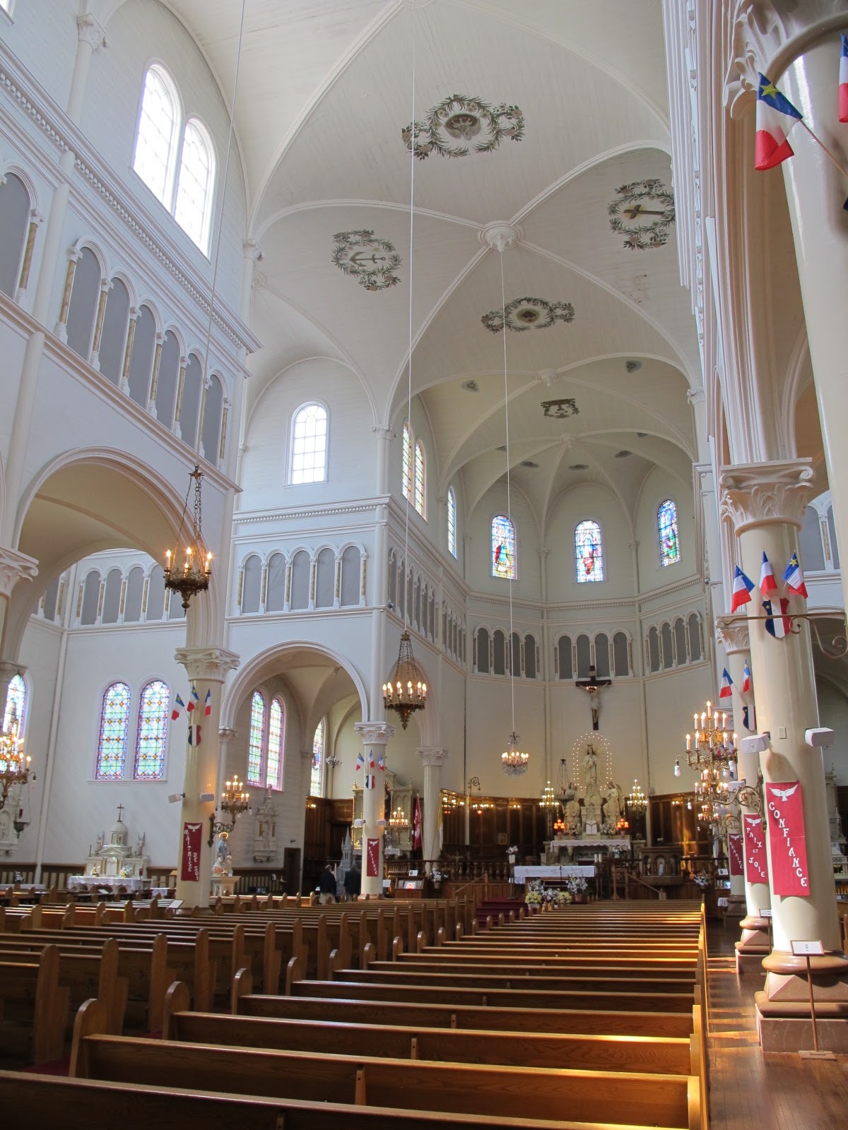
No extravagance, I can assure you - simply what had to be done. Through your legislators, you have spent $310 million to restore one of the finest state capitol's in the country, the Minnesota State Capitol, planned to last at least the next 100 years.  Indeed, my bias will come through if I were to argue as the finest state capitol in the country.  And this restoration, four years in the works, is now complete, and the grand re-opening celebration took place this past weekend.

I spent your money in my capacity as an at-large member of the State Capitol Preservation Commission, appointed by Governor Dayton in 2013, representing all people of Minnesota, and I have been honored to serve you.

It was a fine journey to this celebratory point.  I learned much, about the State Capitol that I had not heretofore known, and grew in the process to really appreciate all that went into its creation.  At times, I felt I was channeling architect Cass Gilbert in 1897, imagining the raging debates, likely with strong political overtones, arguing for the white Georgia marble on the exterior, when the State has an abundance of granite and limestone.  But it had to be white, he insisted, a beacon of the peoples house atop the hill.

Oh, we had our arguments during the process, and why wouldn't we?  This is politics mixed with progress!  It was both very interesting and quite frustrating for me to witness as one of the few non-politicians on the panel, and I was not afraid to speak my mind on your behalf. But I can say that the parties came together well in the end - that is what you would have wanted, rather than the gridlock we experience on other matters of State and Nation these days.  And when it came to the Capitol Art Subcommittee of which I was a part, I learned many lessons - a better understanding of our history through the marvelous artwork, and also the raw pain that some of this artwork imparts.  It is our history, we can be both sorry and proud of parts of our heritage.  The artwork has been wonderfully restored, and is the crown jewel of this marvelous structure.

The Rotunda

And speaking of artwork, I was a lonely voice in support of the event graphics, whose imagery was not so favorable to my august colleagues, perhaps wanting something more in the grand tradition of the Capitol itself.  But I spoke to the youthfulness of the graphical expression - the people's house - reminding my colleagues of their own flirt with the '70's, and how this image may perhaps appeal to the very generation we want to carry on the care and feeding of this marvelous structure.


So it was time to celebrate its completion.  The "party" was not funded by taxpayers, but by donors, one of whom was me, honored to provide a modest contribution - the first received - to fund the raising of more money for this event.

Hope Anderson lecturing the Governor   (photo by Lou Michaels)
I had a front row seat at the ribbon cutting last Friday under a crystalline blue sky, dressing the capitol in an iridescent white glow, listening to all the dignitaries extol the virtues of the capitol, the process and government, but all overwhelmed by the diminutive Hope Anderson, a third grader from Duluth barely tall enough to reach the microphone, the winner of an essay contest, innocently wondering when the first  woman Governor would be "living in the capitol!"  I was honored to be one of the ribbon holders as Governor Dayton cut the wide red ribbon.

The official ribbon cutting (and me back row, holdng on, below arrow)
I then helped my Commission colleague and friend, Ted Lentz, of the Cass Gilbert Society, hand out pieces of the original marble scraps he chipped up to hand out - ultimately distributing 1 ton of rocks to eager, and at times, incredulous visitors that they could actually have this shard of history - for free!  Ted also deserves praise for his tireless efforts on the Commission to open the loggia after so many inaccessible years, and the personal mission to curate a display in the Third floor conference room on the original construction of the capitol.

And in the final day of three celebrating this occasion on Sunday, I was the gatekeeper on the line to the ice cream stands, originally intended for the families of the construction workers following a brief recognition event for current and past workers of the original structure - a well deserved honor for the many that made this work resplendent again.  But thankfully, I held no one back, feigning seriousness to the younger ones by suggesting that they tell me the date the capitol first opened for passage to this aisle of frozen delight (1905).  I admit my ability to settle into a carnival clown's role is overwhelming - which apparently was cited by unknown others who apparently identified me as a particularly "notable" volunteer.  My position was somewhat strategically located, affording me brief face time with many colleagues and notables, including Mayor Chris Coleman and Governor Mark Dayton, who recognized and thanked me on his way to the workers recognition event.

But what really inspired me was to quietly observe the crowds viewing the capitol, pointing to this or that, trying to keep the otherwise bored youngsters engaged, speaking in complimentary terms in awe of the sheer grandeur of the place.  And even a large crowd, seeing up close the enormous paintings of the Treaty of Traverse des Sioux (Frank Mayer, 1885, David Millet 1905)) and the Father Hennepin at the Falls of St. Anthony (Douglas Volk, 1905) paintings, dwarfing the 3rd floor Library and allowing the visitors a moment of quiet reflection upon the history these paintings represent.

And finally, I am humbled - and honored, and deeply so.

Unbeknownst to me, the large, ornate brass plaque recognizing the Capitol's restoration, positioned opposite a similar plaque of 1905, was revealed by the Minnesota State Historical Society on Friday morning.  And there, in approximately the center of the plaque, is my name, noted for posterity.


Thank you for the privilege and honor of serving all people of Minnesota, preserving one of my favorite buildings, for you and your children's children's children.